Bessbrook
Houses within 5km of this house
Displaying 10 houses.
Houses within 5km of Bessbrook
Displaying 10 houses.
| House name | Description | |
|---|---|---|
| Newbliss | This house, now demolished, on the outskirts of the town of Newbliss was the home of the Ker family who held it in fee. Built in 1814, Andre A. M. Ker was the proprietor in the mid-19th century when the buildings were valued at £70. Mary Isabella Murray Ker was the occupant in the early 20th century with over 200 acres of untenanted land. | |
| Glynch/Glinch House | Glinch Lodge is marked on the 1st edition Ordnance Survey map (1836). Sources in the National Library record the will of J. Rogers of Glinch Lodge, 1827. Lewis records J. Thompson as the occupant in the late 1830s. A new house with portico entrance was built slightly to the south in the mid-19th century and valued at £50 in Griffith’s Valuation. It was occupied by Robert Lowry and held from Richard Mayne. At some time in the mid-19th century ‘Glynch’ House was the residence of Charles Stuart Adams who married Eliza McMahon of Rockfield, county Monaghan in 1850. Home of Felix Keirns and his family in 1911. |

|
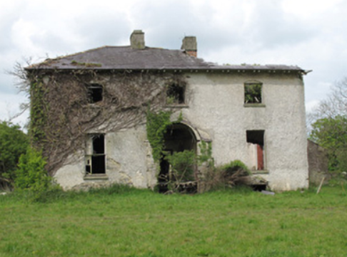
| Ballynure House | Built in the late 18th century, this house was originally the home of the Forster family. Described in the Ordnance Survey Field Name Book as a ‘handsome modern structure’. Griffith’s Valuation records William Forster as the occupant holding the property in fee. The buildings were valued at £50. The Haire Forsters lived here at the beginning of the 20th century but by 1911 were leasing Ballynure to William Maxwell Scott Moore, Resident Magistrate. This house is now a ruin. |
|
| Ashfield | This house located on the Barrett-Lennard estate is marked on the 1st edition 6 inch Ordnance Survey map. James G. Smyth of Ashfield, Clones, was a subscriber to Lewis ‘Topographical Dictionary’ in the 1830s. Valued at £10 Jane Smith was the occupier at the time of Griffith’s Valuation. A house is still located at this site. | |
| Drumcru | A building was located at this site on the Barrett-Lennard estate at the time of the 1st edition Ordnance Survey map (1836). Griffith’s Valuation records the house valued at £11 and occupied by Mary Renwick. A house surrounded by a complex of outbuildings is still located at this site. | |
| Killycoonagh House | Killycoonagh, located on the Forster of Ballynure estate, is marked but not named on the 1st edition 6 inch Ordnance Survey Map (1836). The Ordnance Survey Field Name Book records the house as the residence of the sister of the proprietor Forster of Ballynure. By about 1860 the buildings were valued at £20 and the occupant was Anne Forster. It appears to have been still in the possession of the Forster family in the first part of the 20th century, although it may have been leased out. |
|
| Anlore Cottage | In the mid-19th century Anlore Cottage, in the village of Anlore, was occupied by Jason Crawford and valued at £10. It was held from William Forster. A building is still located at this site. | |
| Gortgranard | This house is marked on the 1st edition 6 inch Ordnance Survey Map (1836) and is named on the 25 inch map (surveyed in 1908). It was the home of the Campbell family, Lewis records Mrs Graham as proprietor. The Ordnance Survey Field Name Book describes the residence of Mrs Graham, widow of Captain Campbell Graham as a ‘good building with large orchards, gardens, out houses etc’. In the mid-19th century it was valued at £20 and held by Samuel Campbell from Thomas de Burgh. Samuel Campbell of Gortgranagh died in 1879 and his wife Mary in 1913. Both are buried in Killeevan COI graveyard. Home of a farming family named Lee at the beginning of the 20th century. | |
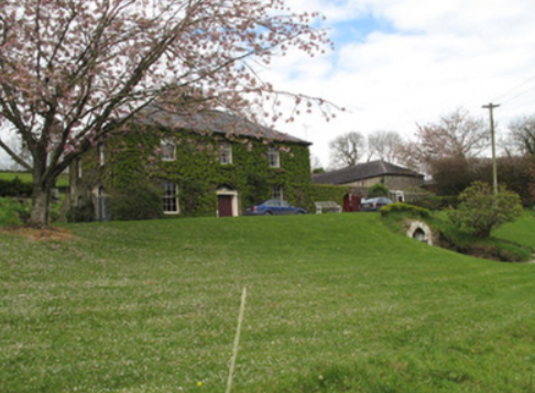
| Lisalea | A house built after the first Ordnance Survey and before Griffith’s Valuation, when the buildings including herds’ houses were valued at £32. It was located on the estate of Andre M. Ker and Richard Wilson was the occupant. In 1901, George Fitzgerald was living in this house with his family as the caretaker for William Edward Ryan. This house is still maintained and occupied. |

|
| Loughoony | An elongated building facing the lake of the same name and marked on the 1st edition Ordnance Survey map (1836). The National Inventory of Architectural Heritage dates this house to circa 1790 and describes it as having a multiple-bay two-storey return. The Ordnance Survey Field Name Book records it as a good dwelling house the residence of Mrs Murray, widow of a Counsellor who was drowned in the lake nearby. In the mid-19th century the buildings were valued at £20 and the house was inhabited by Andrew Clarke who held it from William Ritchie. Loughoony was the home of Samuel Condell and family at the beginning of the 20th century |
|