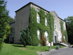
Grenanstown
Houses within 5km of this house
Displaying 10 houses.
Houses within 5km of Grenanstown
Displaying 10 houses.
| House name | Description | |
|---|---|---|
| Lismore | A house on the Toler estate, occupied by John Pepper and valued at £13+ in the mid 19th century. A building is still located at this site. | |
| Lissanisky | The home of a branch of the Pepper family in the 19th century, occupied by Simon Pepper in 1814, by R. Smithwick in 1837. The Ordnance Survey Name Books refer to it as " a good dwelling house, the residence of Mr. Pepper". It was occupied by Theobald Pepper and Brothers in the early 1850s. This house was held from the Honourable O.F.G. Toler and was valued at £25.10 shillings. It is still extant and occupied. |
|
| Pallas | The home of the Short family in the first half of the 19th century held from the Bowens of Bowens Court. John Short was resident in 1814 and 1837. The Ordnance Survey Name Books describe it as "a commodious dwelling with pretty demesne". It was occupied by Edmund Short at the time of Griffith's Valuation when the buildings were valued at £10. A farm is located at the site. | |
| Shanbally | Shanbally was occupied by John Gasson in 1814 but had become the home of Peter Smithwick by 1837. He held the property from Samuel Gason in the mid 19th century when the house was valued at £26.13 shillings. The Ordnance Survey Name Books describe it as "a good dwelling house". In 1894 Slater refers to it as the residence of John Smithwick. It is still extant. |
|
| Ballinamona | A house valued at £11+ on the estate of the Honourable O.F.G. Toler and occupied by Newton Short in the mid 19th century. The Ordnance Survey Name Books refer to it as "a good dwelling house" in 1840. A house is still extant at this location. | |
| Millbrook | Described by Wilson as the seat of Mr. Hawkshaw in 1786, Millbrok was also the home of the Hawkeshaw family in the 19th century, occupied by Richard Hawkshaw in 1814 and of his representatives in the early 1850s, when it was held from George Armstrong and valued at £19+. Millbrook House was included in the sale of the Earl of Listowel's estate in 1861. Michael Dwyer was the tenant. A building is still located at this site. | |
| Norwood | In 1841 the Ordnance Survey Name Books described Norwood as "a good dwelling house occupied by a member of the Minchin family" though Simpson Hackett is noted as the proprietor. Captain David Joyce was resident in the mid 19th century when the house was valued at £15+ and held from Thomas Hackett. This house is still extant. |
|
| Ballymackey House | Ballymackey House is described as "in ruins" at the time of the first Ordnance Survey in the 1830s. An earlier tower house is also shown, described as "Ballymackey Castle (in ruins)". Wilson, writing in 1786, refers to "Ballymakey" as the seat of Mr. O'Meara. The Ordnance Survey Name Books describe Ballymackey House as "an old house adjoining the south side of Ballymackey old castle.....now in a state of total ruin". By the time of Griffith's Valuation, this townland was part of the Cole-Bowan estate. Most of the site is now occupied by extensive farm sheds though ruins of the old castle are still visible. | |
| Tiermoyle House | In 1786 Wilson refers to Tiermoyle as the seat of Mr. Crawford. In 1840 the Ordnance Survey Name books refers toTiermoyle as a residence of Cooper Crawford and "about 20 years ago it was then a place of some account but it is now in a state of dilapidation". By the time of Griffith's Valuation, this house was occupied by Mrs. Costelloe, leasing from Countess Norbury's estate and valued at almost £4. A farm is still extant at the site. | |
| Ballycrenode House | In 1840 the Ordnance Survey Name Books refer to the site of Ballycrenode House in the parish of Kilkeary, stating "only those people who are very old can recollect seeing any part of this house standing". This original Ballycrenode House belonged to the O'Carroll family and the last inhabitant was a Major O'Carroll. The site is marked on the 1st edition Ordnance Survey Map. At that time and in Griffith's Valuation, the townland belonged to the Toler estate. The 25-inch map of the 1890s shows a later Ballycrenode House, located slightly to the north-west of the original site. This property is still extant, part of a large farm. |