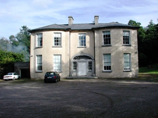
Ballynamultina House
Houses within 5km of this house
Displaying 12 houses.
Houses within 5km of Ballynamultina House
Displaying 12 houses.
| House name | Description | |
|---|---|---|
| D'Loughtane | The Ronayne family were resident at D'Loughtane for many centuries. It was lost to the family in the 17th century but recovered through marriage with a Bluett. In the eighteenth century Smith refers to it as "the pleasant seat of Mr. Ronayne". The original house was destroyed by fire and a new one built in the early 19th century. At the time of Griffith's Valuation, it was held in fe by Robert P. Ronayne and valued at £26. The sale rental of June 1851 states that it was erected at a cost of £3,500. Knight writes that it was sold in the Encumbered Estates Court in 1856 to Mr Samuel Allen who sold it later to John Pedder Furlong of Fermoy. Furlong sold the property to the Land Commission in 1910. The house has had a number of occupiers since then and is now owned by the Smiddy family. |
|
| Cooneen Mill | Charles Musgrave was leasing this extensive property from Sir Richard Musgrave at the time of Griffith's Valuation, when it was valued at £31 5s. It is recorded as disused on the 25-inch Ordnance Survey Map of the 1890s. Some ruins remain at the site. | |
| Shanakill (Decies) | In 1851, this property was leased by Edmund Dower from Thomas J. Fitzgerald when it was valued at almost £10. A house and farm are still extant at this location. | |
| Tinnascart House | In 1851 this property was leased by Robert Dower from William C. Poole when it was valued at £14 10s.The 1874 Dower estate sale notice indicates that the house had been built within the previous 15 years at a cost of £2000. It is labelled as Tinnascart House on the 25-inch Ordnance Survey map of the later nineteenth century. The location is now a racehorse training enterprise. | |
| Laurentum | At the time of Griffith's Valuation, Richard Coughlan was leasing this property from the Villiers-Stuart estate, when it was valued at £11. It does not appear on the 6-inch Ordnance Survey map but is named as Laurentum on the later 25-inch map. There is still an extant house at the site. | |
| Clashmore | Clashmore was held in fee by the Earl of Huntingdon at the time of Griffith's Valuation, when it was valued at £34. The site marked on the 1st-edition Ordnance Survey map is not that recorded on the later 25-inch map. Smith refers to the earlier house as the seat of Mr. Power and Wilson refers to it as the seat of Richard Power in 1786. The Irish Tourist Authority Survey of the 1940s suggest the later house was never fully completed and by then had all but disappeared. Much of the extensive farmyard, however, is still extant and in use. |
|
| Bayview (Clashmore) | Rev. Michael Purcell was leasing this property from Lord Decies estate in 1851 when it was valued at £12. There is still an extant house at this site. | |
| Rockview (Clashmore) | Leased by Richard Bayley from the Villiers-Stuart estate at the time of Griffith's Valuation, when it was valued at almost £7. It is labelled Rockview on both the 6-inch and 25-inch Ordnance Survey maps. There is still an extant house at the site. | |
| Glenlicky Mill | At the time of Griffith's Valuaton Rev. James Elliott was leasing this substantial property to Thomas Page, when it was valued at £44. It included a house and mill. Noted on the 25-inch Ordnance Survey Map of the later nineteenth century as Glenlicky Mill. The buildings are now ruinous. | |
| Lackendarra House | In 1851, Mrs. Eleanor Fitzgerald was leasing this property from Rev. James Elliott when it was valued at £11 5s. In 1894 it appears to have been occupied by a Russell family. | |
| Lackandarra Lodge | At the time of Griffith's Valuation, Richard Chearnley held this property in fee when it was valued at almost £10. On the 25-inch Ordnance Survey Map of the 1890s it is labelled Lackandarra Lodge. A farm is still extant at the site. | |
| Lackandarra A | Mrs. Eleanor Power was leasing this property from the Chearnley estate at the time of Griffith's Valuation, when it was valued at £9. There are still buildings extant at the site. |