Killough
Houses within 5km of this house
Displaying 15 houses.
Houses within 5km of Killough
Displaying 15 houses.
| House name | Description | |
|---|---|---|
| Ballinree | Ballinree House was valued at £16+ in 1850 and was occupied by the Reverend William Kirwan and held from Smyth Barry. Arthur H.S. Barry was the occupier in 1906. | |
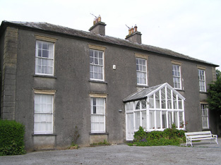
| Ballytarsna | John Max occupied this house which he held from the Bunbury estate in 1850. The buildings were valued at £16.12 shillings. In 1906 James Grene was resident. Recently renovated this house is still well maintained and occupied. |
|
| Gaile | Gaile was the home of the Phillips family in the 19th century, occupied by S. Phillips in 1837 and by Richard Phillips in 1850. It was held from Benjamin Bunbury with 749 acres and was valued at £37+. The Phillips continued to reside at Gaile until at least the mid 20th century. This house was vacant in the early 21st century. |
|
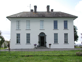
| Regaile | In 1840 the Ordnance Survey Name Books record Rev. Mr. Joice as the occupant of Regeale. The Reverend Robert Armstrong occupied the house at the time of Griffith's Valuation holding it from Richard Phillips. The buildings were valued at £20.18 shillings.A house is still extant at Regaile. | |
| Grallagh Castle | In 1840 the Ordnance Survey Name Books refer to Mr. Hodgins as resident at Grallagh House. Southery Mansergh occupied the house,valued at £14+ in the mid 19th century. He held this property from O'Connor Hinchy. It is labelled Grallagh House on the 1st Edition Ordnance Survey map but as Grallagh Castle on the 25-inch map of the 1890s. It is no longer extant. | |
| Graiguenoe | In 1837 Lewis refers to C. Clarke "who has recently erected a spacious and elegant mansion on his estate". In 1850 this mansion was valued at £44.12 shillings and it was held in fee by Charles Clarke. Slater noted it as the seat of James Neville Clarke in 1894 and the Clarkes were still resident at Granguenoe Park in the early 20th century. The house was burnt in 1923. The site is now occupied by a stud farm. | |
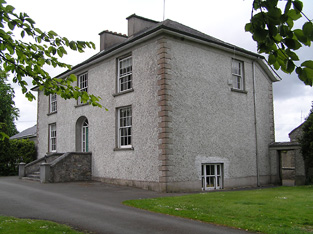
| Parkstown | The Lamphiers were resident at Parkstown from at least the 1770s. In 1786 Wilson refers to Parkes-town as the seat of "Mr. Lanphier". Henry Langley lived at Parkstown in 1814 and John P. Lamphier was resident in 1837 and in the early 1850s. Lamphier held the property from the Court of Chancery and the buildings were valued at £23+. John P. Lanphier was the occupant at the time of sale in 1852. This building is still a fine residence. |
|
| Cabragh Castle | The home of James Fogarty in 1814. In 1840 the Ordnance Survey Name Books refer to P. Fogarty as the proprietor of "Cabra House". Denis Leahy was the occupier in the mid 19th century when the castle was valued at £16+ and held from the Court of Chancery. | |
| Maxfort House | Maxfort was the home of John Max in 1814 and of William Max in 1837 and at the time of Griffith's Valuation. It was held from Viscount Hawarden and valued at £15.18 shillings. A house is still extant at the site. | |
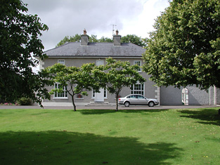
| Laurel Lodge | In the mid 19th century Vernon Lamphiere occupied a house in the townland of Moycarky held from William Max and valued at £13.5 shillings. A house is still extant at the site. | |
| Beakstown House | Major Ledwell was resident at Beakstown in 1837 and the Ordnance Survey Name Books also mention it as his residence in 1840. At the time of Griffith's Valuation one house at Beakstown appears to be in use as an auxiliary poorhouse, held by the Reverend George Peacock from the Court of Chancery and valued at £22+. Another property seems to be labelled Abbey View on the 1st Edition Ordnance Survey map but as Beakstown Cottage on the 25-inch map of the 1890s. The OS Name Books refer to this house as the residence of Mr. Mullvany, proprietor of Beakstown Flour Mills nearby. The name Beakstown Cottage had previously belonged to another property in Beakstown which is still extant [S087559]. The original Beakstown House does not appear to be extant. | |
| Shanbally House (Moycarkey) | In 1786 Wilson refers to Shanbally as the seat of Colonel Slaughter. In1840 the Ordnance Survey Name Books note that "Shanbally Old Castle" was the name given to a house in the parish of Moycarkey. By the time of Griffith's Valuation the townland is part of the estate of Miss Emma Stannix. A house is still extant at this site, now part of a large farm. | |
| Holycross House | In 1840 the Ordnance Survey Name Books refer to Holycross House as a gentleman's residence. At the time of Griffith's Valuation, it was owned by Rev. Garret Wall but was unoccupied. The house was valued at almost £24. A house still stands at this site which now appears to be in use as a presbytery. |
|
| Abbeyfield / Gortnagowth | In 1840 the Ordnance Survey Name Books refer to Abbeyfield House as the residence of William Jones. At the time of Griffith's Valuation, Jeremiah O'Brien was leasing this property from the Wall estate when it was valued at £15+ and included a mill. It is labelled Abbeyfield on the 1st edition Ordnance Survey map but as Gortnagowth on the 25-inch map of the 1890s. It is still extant. | |
| Whitefort House | The Ordnance Survey Name Books refer to Whitefort House as a gentleman's residence in 1840. At the time of Griffith's Valuation, this property was leased by John Jones from the Wall estate when it was valued at almost £10. It is still extant. |