Kilcooly Abbey
Houses within 10km of this house
Displaying 12 houses.
Houses within 10km of Kilcooly Abbey
Displaying 12 houses.
| House name | Description | |
|---|---|---|
| Ballyphilip | The seat of the Going family in the 18th and 19th centuries, W. and A. Going were resident in 1814 and Ambrose Going held the property in fee at the time of Griffith's Valuation. The buildings were valued at £30.15 shillings. This house was held by the representatives of B.F. Going in 1906. Buildings are still extant at the site. | |
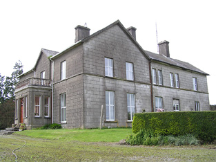
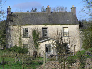
| Coalbrook | A Langley home in the 18th and 19th centuries. The Ordnance Survey Name Books describe the demesne as "nearly one half wood and oranmental ground" in 1838. It was valued at £35.10 shillings in the mid 19th century when held by Henry Langley in fee. George Langley was the occupier in 1906 when the buildings were valued at £41+. This house is still extant and lived in. |
|
| Lisnamrock Castle | The Langleys were resident here from the 18th century. Wilson, writing in 1786, refers to Lisnarock as the seat of Mr Langley. Henry Langley was the occupier in the mid 19th century, holding the property in fee. The buildings were valued at £11.10 shillings. Held by George Langley in 1906. Buildings still exist at this location. | |
| Pastor Ville [Kockboy] | In 1840 the Ordnance Survey Name Books refer to Pastorville as a gentleman's seat and to Micheal Meeghan as the proprietor. At the time of Griffith's Valuation Timothy Meighan held a house at Knockboy valued at £10.15 shillings and 15 acres from Edmund Byrne. This appears to be the house Pastor Ville marked on the first Ordnance Survey map and on the later 25-inch map of the 1890s. Buildings are still located at this site. | |
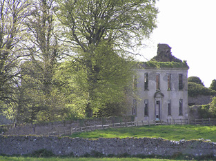
| Littlefield | Littlefield, Killenaule, was the residence of Flor Carrol in 1814 and of E. Cooke "who occasionly resides here" in 1837. Earlier, in 1786, Wilson had referred to it as the seat of Mr. Cooke. Edward Cooke is recorded as the occupier at the time of Griffith's Valuation. He held the property in fee and the buildings were valued at £12. This house is now a ruin. |
|
| Poyntstown | A home of a branch of the Cooke family in the 18th century. In 1786 Wilson refers to "Point's-town" as the seat of William Cooke. He was also the proprietor in 1814. In 1837 Lewis records Poyntstown as the property of Phanuel Cooke "in ruins". The house is marked as in ruins on the first Ordnance Survey map. Fennell Cooke held this townland at the time of Griffith's Valuation. | |
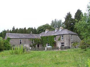
| Glenview | Glenview was occupied by the Reverend Edmund Prendergast in the early 1850s. He held the house valued at £18.15 shillings from Matthew Prendergast. In the early 20th century the house was altered and extended by a religious order who set up a school. |
|
| Grangehill | Robert Mason held a house and office valued at £15.10 shillings at Grangehill from William P. Barker in the mid 19th century. Mason was Barker's agent. He also held offices and 101 acres in the neighbouring townland of Knockatooreen. | |
| George's Park | Located on the Barker estate this house may be named after George Ashby who lived in it in the mid 19th century. It has been extended since it appeared on the first Ordnance Survey map and was valued at £13.10 shillings at the time of Griffith's Valuation. It is still extant and occupied. |
|
| Newhill | A property belonging to the Going family in the late 18th and 19th centuries. Newhill was the home of James Going in 1814 and of John Thomas Going, son of Samuel Murray Going, in the mid 19th century. The buildings were valued at £18.12 shillings at this time and held from Christopher Donville. Newhill passed to John Thomas Going's sister Mary Braddell who was resident in 1906. | |
| Slievardagh | In 1906 John H. Lanphier held buildings valued at £18+ in the townland of Blackcommon part of the village of Commons, probably Slievardagh House. This house is not marked on the first edition Ordnance Survey map. |
|
| Venter Fair | The Ordnance Survey Name Books refer to this house in the townland of Clashduff, parish of Ballingarry as "Venture Fair" and note the existence there of coal mines of the same name. At the time of Griffith's Valuation, it was leased by Mrs. Mary O'Sullivan from the Langley estate and valued at almost £10. A house is still extant at the site. |