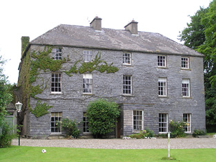
Neddans
Houses within 5km of this house
Displaying 13 houses.
Houses within 5km of Neddans
Displaying 13 houses.
| House name | Description | |
|---|---|---|
| Kilgrogy House | A Clutterbuck home, occupied by Thomas Clutterbuck in 1814. The Ordnance Survey Name Books refer to it as the residence of Samuel Clutterbuck in 1839 and mention that it was in bad repair. Lewis refers to it as the seat of L. Clutterbuck in 1837 and Samuel Clutterbuck was the occupier in the early 1850s. He held the property from Viscount Lismore. The buildings were valued at £14. A building is still located at this site. | |
| Monroe House | Charles Browne was occupying this house in the early 1850s. He held it from the Earl of Glengall and the buildings were valued at £10. A house and farm are still extant at the site. | |
| Rochestown | Rochestown came into the possession of the Barton family through the marriage in 1798 of Dunbar Barton and Elizabeth Riall. In 1837 Lewis describes Rochestown as the seat [of their son] S. Barton. Samuel Barton was resident in the early 1850s holding the house valued at £37 from a member of the Beamish family. The National Inventory of Architectural Heritage records the remodelling of the house in 1867 by the Wise family, the design by Sir Thomas Newman Deane. The house was valued at £55 in 1906 and occupied by Francis H. Wise. Damaged by fire in 1918 and completely destroyed by fire in February 1923. |

|
| Corrabella | In 1840 the Ordnance Survey Name Books describe this house as "a very good building in bad repair, the residence of Miss Ann Mulcahy". It was leased to William Mulcahy by the Glengall estate and occupied by him in the mid 19th century when it was valued at £18+. A lithograph of this building is included in the sale rental of November 1853. The Mulcahys were still resident in the 1950s. This three storey house still functions as a residence. |
|
| Greenmount (Molough) | Originally the home of a branch of the Greene family of Kilmanahan. Occupied by Robert Prendergast in 1814. In 1841 the Ordnance Survey Name Books refer to it as the residence of Richard Butler Hamilton Low. It was leased by Southwell Mulcahy at the time of Griffith's Valuation, when the house was valued at £24 and held from the Reverend William Pennefather. Marked on the first Ordnance Survey map as Greenmount, this house is now known as Kenilworth House. |
|
| Burgesland House | In 1841 the Ordnance Survey Name Books refer to Burgesland House as "a gentleman's place, the residence of Thomas Mulcahy". The house was valued at £16+ in the mid 19th century. It was occupied by Thomas Mulcahy and held from Edward Pennefather. Some ruined buildings are extant at the site. | |
| Lacken | In 1840 the Ordnance Survey Name Books noted Lacken as the residence of "Pendergrass", a house in very good repair. John Mulcahy occupied the house valued at £15+ at Lacken in the mid 19th century. He held the property from William Ryan. This house is no longer lived in. |

|
| Carrigataha | The home of W.J. Fennel in 1837 and in 1840. The Ordnance Survey Name Books describe it as "very pleasantly situated and in good repair". It was occupied by Thomas Fennell in the early 1850s. Thomas held the property from a member of the McCarthy family and the buildings were valued at £15. Buildings are still located at this site. | |
| Marlfield | Built by Colonel John Bagwell MP in the late 18th century in the Palladian style. It was the seat of the Bagwell family of Clonmel in the 19th and 20th centuries, held from the Moores of Barne and valued at almost £83 in the early 1850s. The central part of the house was burnt in 1923 and rebuilt in 1925 and is now in use as an apartment complex. |

|
| Ardfinnan Castle | A building that has been added too and altered since the 15th century. Occupied by James Prendergast at the the time of Griffith's Valuation, held from the Ecclesiastical Commissioners and valued at £13. In 1894 Slater notes it as a residence of Mrs. Prendergast. Still in use as a residence. |

|
| Whitesfort | At the time of Griffith's Valuation John Norris was leasing this property from the Stradbroke estate when it was valued at £11. Referring to the 1770s Sadleir notes "John White, of Whitefort" who was married to a daughter of Ambrose Lane. It is not named on the 1st edition Ordnance survey map though buildings and a walled garden are visible. The ruins of some buildings remain. | |
| Suir Mount | The representatives of James Fitzpatrick were leasing this property to John Egan in 1850 when it was valued at £13 11s. The house was included in the sale of the estate in May 1850 when it was described as " a good substantial dwelling house". | |
| Newcastle | Lewis writes that the only seat in the parish was the residence of S. Mulcahy. The Ordnance Survey Name Books, in 1840, mention that Newcastle House was then "in very bad repair". In the mid 19th century Miss Anne Mulcahy held the house valued at £12 from John Gordon, medical doctor, who held from the Perrys. In the 1870s William Perry is described as "of Newcastle". Elizabeth Perry occupied this house valued at £22+ in 1906. It is no longer extant. |