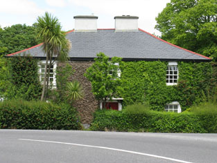
Brook Ville (Kilmacabea)
Houses within 5km of this house
Displaying 7 houses.
Houses within 5km of Brook Ville (Kilmacabea)
Displaying 7 houses.
| House name | Description | |
|---|---|---|
| Brade House | John Swanton was leasing this property from Rev. Maurice Townsend at the time of Griffith's Valuation, when it was valued at £15 10s. Lewis had noted it as the seat of Rev. E.P. Thompson in 1837. It was the residence of Samuel Jervois in 1814. Taylor and Skinner's 1783 map also indicate it as a Jervois residence. In 1786 Wilson refers to it as the seat of Mr.Jervis. In 1906 it was owned by Katherine Townsend and valued at £44 5s. There is still an extant house at the site. | |
| Cashel House (Kilmacabea) | William Wolfe was leasing this property, then valued at £12, from Miss Wheeler, at the time of Griffith's Valuation. Local records suggest the family were associated with this house since the eighteenth century. The original house is no longer extant and a modern house exists at the site now. | |
| Cloonkeen House (Kilmacabea) | Leased by Sarah Dorman to Florence McCarthy in 1851 when the house was valued at £9. A house still exists at the site. | |
| Connonagh House | John Morris was leasing this property to Barbara Jago in 1852 when it was valued at almost £8. There is still an extant house at the site. |

|
| Kilmacabea Mill | John Sheehan was leasing this property from the Bennett estate in 1852, when it was valued at almost £13 and included a mill. A corn mill, then disused, is shown on the 25-inch Ordnance Survey map of the 1890s. A building still exists at the site. | |
| Westwood/Benduff Cottage | Catherine French held this property from William Morris at the time of Griffith's Valuation. On the 25-inch Ordnance Survey map of the 1890s it is labelled Westwood. In 1906 it was owned by Michael French and valued at £13 10s. There is still an extant house at the site. | |
| Cellmount House | Wilson, writing in 1786, refers to "Selmount House" as a seat of Mr. Morris, three miles from Ross Carbery. This property is labelled "Cellmount House, in ruins" on the 1st edition Ordnance Survey map and there is no trace of it on later maps. |

