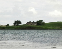
Rinroe House
Houses within 5km of this house
Displaying 9 houses.
Houses within 5km of Rinroe House
Displaying 9 houses.
| House name | Description | |
|---|---|---|
| Cottlestown | The Kirkwood estate was centred on Cottlestown House. The name seems to have sometimes been known as Castletown and this is how it appears on the First ed. OS sheet but documentary evidence would seem to suggest the estate was also known as Cottlestown. The Buildings of Ireland survey states that it is likely that the present house was added to an earlier, probably eighteenth century structure, which in turn replaced the fortified house on the site. On modern OS sheets the townland is known as Cottlestown. This property later became part of the Boyd estate. |

|
| Moyview | Moyview was part of the Wingfield estate but was let to other families at different times. At the time of Griffith's Valuation, it was being leased by Robert Warren and was valued at £12. There is still an occupied house at this site though McTernan notes that the original house was an eighteent-century single story thatched residence. | |
| Knockroe | Knockroe house was part of the Wingfield estate and at the time of Griffith's Valuation was valued at £12. The property is now part of a farm. The remains of the entrance gates are supported by an iron bedpost! | |
| Scurmore | In 1786 Wilson writes that Scurmore House was the seat of Mr. Nisbett. Later, in the nineteenth century it became a seat of the Wingfields. In the 1830s it is described as undergoing repairs but the family were again occupying it by 1857. The house is recorded as the property of S.L. Lewis in 1906 when it was valued at £37. McTernan states that the house was demolished in the mid twentieth century. A later house now exists at the site but the original outbuildings are still intact. | |
| Rosserk | Captain Green resided here in the 1830s. At the time of Griffith's Valuation, Capt Augustus Bolton was occupying a property valued at £10. On the 25-inch Ordnance Survey map of the 1890s a different building, adjacent to a large corn mill and located at G243252, is labelled Rosserk House. Buildings are still extant at this site. | |
| Broadlands | The home of the Knox Gore family, let to Patrick C Howley in the 1830s. It was leased by John Knox, of the Rappa Castle family, at the time of Griffith's Valuation when the house was valued at £15 10s. . A house is still extant at this site. | |
| Bartragh House | A Kirkwood family home in the 19th century. At the time of Griffith's Valuation, the property was leased by William Hopper from the Kirkwood estate when the buildings were valued at £16. A house is still extant at the site though in a dilapidated state. |
|
| Moyne Abbey | Associated with the Lindsey family in the 17th century it was leased to the Knoxes by James O'Hara, Lord Tyrawley, for 999 years in 1741. The Knoxes built a private residence on to the east end of the friary. At various time the Jones, Palmer and Kirkwood families leased parts of Moyne. Thomas Jones sold his interest in the Landed Estates' Court in 1867. The Ordnance Survey Name Books record that Peter Nolan, agent to Sir William Palmer, lived in a neat cottage in the east of the townland. This may be the property labelled Moyne House on the 25-inch Ordnance Survey map of the 1890s (G228287), the remains of which are still extant. | |
| Orme's Lodge | Robert Orme was the owner of several properties in the village of Enniscrone, Carrowhubbuck South, barony of Tireragh, at the time of Griffith's Valuation. These properties had valuations of between £12 and £20. McTernan notes that one of these was Orme's Lodge which remained in the family until the 1930s. It subsequently became a hotel and was demolished in the 1990s to make way for new house building. |
|