Druminshin Glebe
Houses within 10km of this house
Displaying 20 houses.
Houses within 10km of Druminshin Glebe
Displaying 20 houses.
| House name | Description | |
|---|---|---|
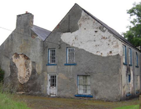
| Kilbracken | William Murray Hickson was leasing the house at Kilbracken, barony of Carrigallen, from Elizabeth Armstrong at the time of Griffith's Valuation when it was valued at £20. In 1814 a house at Kilbracken was recorded as the residence of Mr. Armstrong but it has been estimated that the present Kilbracken House was built around 1825. It is not named on the first edition Ordnance Survey map though there are buildings marked on the site. A poster in Leitrim County Library indicates that it was the property of Thomas S.Jones in 1905 when it was offered for sale. The house is still extant and undergoing restoration. |
|
| Killygar | It is estimated by the National Inventory of Architectural Heritage that Killygar was built in 1813. At the time of Griffith's Valuation Killygar House was occupied by John Godley and was valued at £43. It was also the residence of John Godley in 1814 and in 1837. In 1894 Slater refers to it as the seat of Archibald Godley. It is still extant and occupied by the Godley family. |
|
| Woodford | Woodford was the residence of Robert J. Gore at the time of Griffith's Valuation when it was valued at £15. In 1814 it was occupied by John Gore. Both Taylor and Skinner and Wilson also record it as a seat of the Gore family in the 1780s. The house at Woodford Demesne, described as "formerly the residence of the Rev. Gore" was "formerly a genteel residence but now in a ruinous state" at the time of the first Ordnance Survey in 1835. Lewis records it as the seat of Ormsby Gore in 1837. In 1906 it was the property of Emily Upperton and was valued at £19. The National Inventory of Architectural Heritage states that it retains little original fabric but much of the estate architecture, including the site of the walled garden survives. There is also an earlier castle at this site. |
|
| Cloghlough | At the time of Griffith's Valuation, William O'Brien was leasing a property valued at £8 at Cloghlough, barony of Carrigallen, from the estate of John King, which was in Chancery. Substantial farm buildings exist at this site. | |
| Drumsillagh | Acheson O'Brien was leasing the property at Drumsillagh, barony of Carrigallen, from the King estate (in chancery) at the time of Griffith's Valuation when it was valued at £15. Lewis also records it as a seat of the O'Brien family in 1837. In 1906 Drumsillagh was owned by the representatives of William A. O'Brien and was also valued at £15. There appears to be still a house at this site. | |
| Corduff House | The National Inventory of Architectural Heritage estimates that Corduff House was built c.1780. William Penrose was occupying the house at Corduff, barony of Carrigallen, at the time of Griffith's Valuation when it was valued at £8. Corduff House is recorded as the seat of the Penrose family by Lewis in 1837. In 1814 it was the residence of George Percy. The house is still extant and occupied. |
|
| Willowfield | Alexander Percy was occupying the house at Aghatawny, known as Willowfield, at the time of Griffith's Valuation when it was valued at £10.Lewis records it as a seat of the Percy family in 1837. In 1814 it was the residence of William Shanley. Both Taylor and Skinner and Wilson also record it as a seat of the Shanley family in the 1780s. The building is still extant. | |
| Garadice | John Percy was leasing the house at Garadice, barony of Carrigallen, from the representatives of William Percy at the time of Griffith's Valuation when it was valued at £15. In 1814 it was noted as a residence of the Percy family. Lewis records it as the seat of W.C. Percy in 1837. In the 1780s both Taylor and Skinner and Wilson noted Garadice as a Percy residence. The ITA survey recorded it as much deteriorated in the 1940s. It also mentions the existence of a second house belonging to the Percy family in the townland of Carrickmakeegan. The buildings are still extant at Garadice. | |
| Riversdale | Matilda Shanley was leasing Riversdale House at Corrachole to William Lawder in the 1850s when it was valued at £12. In 1837 Lewis records it as the seat of the Shanley family. It is still extant and operates as a farm guesthouse. |
|
| Clooncorick Castle | Formerly an O'Rourke castle, Clooncorrick was held by several other families, notably the Irwins, before being bought by Pierce Simpson in 1835. In 1814 it is recorded as the residence of Rev. Agar. At the time of Griffith's Valuation it was being leased by Pierce Simpson from the Ormsby Gore estate and was valued at £40. Lewis also records it as the seat of the Simpson family in 1837. In the 1930s the castle was dismantled and the fittings sold. The ITA survey in the 1940s recorded that the castle had recently been demolished. | |
| Lawderdale | The National Inventory of Architectural Heritage survey states that Lawderdale was built in the early 1850s and has a tower which was added in the 1870s. At the time of Griffith's Valuation it was the property of William Lawder and was valued at £18. In 1906 it was the property of James Ormsby Lawder and was valued at £30. It is still extant. |
|
| Cottage Vale | At the time of Griffith's Valuation Charles Ensor was leasing a property valued at £10 at Drumdarkan, barony of Mohill, to George West. There is still an occupied house, part of a large farm, at this site. |
|
| Cloone Grange | A house built after the publication of the first Ordnance Survey Map. At the time of Griffith's Valuation Rev. John Carson was occupying the property which was valued at £25. In 1906 William H. White was the owner of this house, valued at £28. The site of the original house is now occupied by farm buildings. | |
| Boeeshil House | At the time of Griffith's Valuation William Shanley was leasing a property at Boeeshil, barony of Carrigallen, incuding a house and corn mill, valued at £20, from the Percy estate. There are three mills shown at the site on the 1st edition 6" OS map, including a corn, bleach and flax mill. Lewis records this property as belonging to the Gerard family. | |
| Mackan | William Faris was resident at ‘Mackin’ in 1814. Lewis records Mackenwood as the home of M. Galbraith. It was part of the estate of William James Thomas Galbraith advertised for sale on in 1851 and 1852. At the time the building was described as a 'thatched house of two stories, not in good repair but as the out-offices are excellent and the lawn and aspect cheerful, it would suit for a Gentlemen's residence'. In the 1850s Captain John Johnston was the owner and occupier. The building was valued at £7 for rates. The house is marked as ‘in ruins’ on the 25 inch map but the stable block is still extant. | |
| Aubawn | Described by Mulligan as a ‘medium-size Late Georgian villa’. In 1814 Henry Lenauze was resident at Aubawn, Killeshanadra and Lewis records Aughabawn as the home of the Reverend J. Vernon. The Upton Papers (RIA) contain the will of M. Story of Aubawn, 1817. By the mid-1850s Richard Fox was the owner and occupier of Aubawn, with a rateable valuation of £21. In 1876 the address of George De La Poer Beresford, owner of 570 acres in the county, was Auburn, Killeshandra. Douglas G. Adams occupied the house in 1901, holding it from Beresford while a land steward William Gordon and his family were resident in 1911. This house has been renovated and modernised. |
|
| Croaghan House | A small house named on the first edition six inch Ordnance Survey map (publ. 1837). The building was later extended and in the mid-1850s was occupied by the Reverend Allan, who held it from Richard Carson. It was valued at £11. David Hamill Crawford, land agent, and family were resident in the early 20th century, this building appears to be still extant. | |
| Laurel Bank/Holly Bank | This house, originally known as Laurel Bank, is named on the first edition six inch Ordnance Survey map (publ. 1837). It is shown in a demesne which included an old bleach mill and a corn mill and kiln. It is believed to have been built by a mill owner in the 18th century. Griffith’s Valuation records William Norton as the occupant holding the property valued at £8.10.0. from the Earl of Gosford. The house is called Holly Bank on the 25 inch map. Altered and added to in the 20th century it continues to be a residence. | |
| Tully House (Killashandra) | Richard Young of Tully 1808, see GO MS. Richard Young and his wife Bridget Nugent Reynolds later lived at Fort Lodge, on the outskirts of Cavan town. In 1814, Mr R.Y. Reynolds was resident at Tully, Crossdoney. Major Randal Stafford of Tully House, Crossdoney, is listed as a subscriber to Lewis ‘Topographical Dictionary’ (1837). In the 1850s this house was occupied by William Magee who held it from the representatives of Hugh Walsh. The Douglas family were resident at the beginning of the 20th century. | |
| Rockfield (Killashandra) | The National Inventory of Architectural Heritage dates this house to circa 1720. The Irish Genealogist Vol II refers to the will of F. Young of Rockfield, 1777. Situated close to Rockfield Lough it was a Berry home in the first half of the 19th century. Thomas Berry was resident in 1814 and in 1851 (Thom’s Directory). Rockfield was advertised for sale in the Encumbered Estates Court in November 1851. A few years later Griffith’s Valuation records Robert O’Brien as the occupant of Rockfield holding it from Oliver Sproul. It was valued at £17. The house is still extant but no longer in use. |
|