Ballyglassin House
Houses within 5km of this house
Displaying 14 houses.
Houses within 5km of Ballyglassin House
Displaying 14 houses.
| House name | Description | |
|---|---|---|
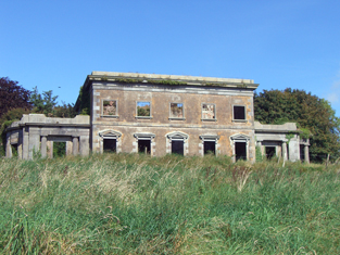
| Dromdihy | The building of this house was completed in 1833 for Roger Green Davis. He is recorded as the occupier in the early 1850s holding the house valued at £45 from Sir Arthur De Capell Brooke. The sale rental of 1863 gives a detailed description of this house - "Drumdiah House consists of a centre and two wings, ornamented with Doric columns and with a portico at the eastern end, by the hall is entered, and off which are hot, cold, vapour and shower baths. The first floor comprises five sitting-rooms; on the second floor are four best bedrooms, with dressing-rooms and water-closet......". In the 1940s the Irish Tourist Association Survey reported that the house had been "destroyed in the Troubles". It is now a ruin. |
|
| Gortnagappul | This area is marked as the farmyard of Aghadoe House on the first Ordnance Survey map. At the time of Griffith's Valuation a house and offices valued at £28 were held by Roger G. Davis from Richard Uniacke Bailey. A large farm complex exists at the site now. | |
| Aghadoe House (Killeagh) | Lewis writes in 1837 that “The present house is about to be replaced by a castellated mansion”. The earlier house is referred to by Wilson in 1786 as the seat of Simon Dring. Aghadoe wasccupied by Thomas M. Green at the time of Griffith's Valuation. The house, valued at £27, was held by him from Sir Arthur De Capell Brooke. The house is no longer extant. | |
| Mount Uniacke | A home of the Uniacke family in the 18th and 19th centuries, occupied by three generations of persons named Norman Uniacke in the 19th century. Earlier, in 1786, Wilson refers to it as the seat of James Uniacke. In the mid 19th century it was held by Norman Uniacke in fee and the house was valued at £30. The Irish Tourist Association Survey of the 1940s reported that it had been burnt in 1921 and it is no longer extant. | |
| Cornaveigh | A house in this townland was occupied by George Bowles in the mid 19th century, valued at £17 and held from his father, Spotswood Bowles. The original building is no longer extant. | |
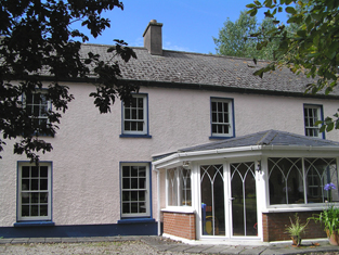
| Mountbell | In 1786 Wilson refers to Mount Bell as a residence of the Garde family. It was ccupied by Edmund MacKey in 1814 and by Edward Lane in the early 1850s. Lane held the house valued at £10 from Sir Arthur De Capell Brooke. A house and large farm are still extant at the site. | |
| Park | Located on the Ponsonby estate The Park was occupied by John Hudson junior in 1814 and by Robert Hudson in the early 1850s when the house was valued at £10. The Hudsons may have been agents to the Ponsonbys. The address of Charles W. Talbot Ponsonby is given as Park House, Youghal in the 1870s. | |
| Burges House | This house, valued at £14, was occupied by William Hall at the time of Griffith's Valuation and held from Lord Ponsonby. | |
| Inchiquin House | In the early 1850s Henry Hall occupied this house valued at £15 located on the Ponsonby estate. | |
| Knockmonalea House | A house valued at £14, the home of John Hudson at the time of Griffith's Valuation and held from Lord Ponsonby. | |
| Aghavine | Occupied by Michael Neville in the early 1850s, held from Francis Wyse and valued at £20. |
|
| Mary Ville | Mary Ville is marked on the first Ordnance Survey map. In the early 1850s the house was occupied by John Hurley who held it from Colonel George Teulon. It was valued at £10. A house is still extant at the site. | |
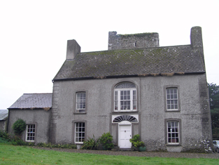
| Castlerichard | Occupied by Richard Fitzgerald in 1814 and in 1837. This house was unoccupied at the time of Griffith's Valuation and held by Thomas John as immediate lessor. It was valued at £9. Advertised for sale in 1858 as part of the estate of Bowles, John and others. This early 18th century house, with the old tower house nearby, is still extant and occupied. |
|
| Ballyvergan House | In 1786 Wilson refers to Ballyvergin as the seat of Robert Uniacke. By the time of Griffith's Valuation, this townland is part of the Leader estate. The house, valued at £12 was occupied by James O'Brien. This may be the property labelled Ballyvergan House on the 25-inch Ordnance Survey map in the 1890s.Buildings still exist at the site. |