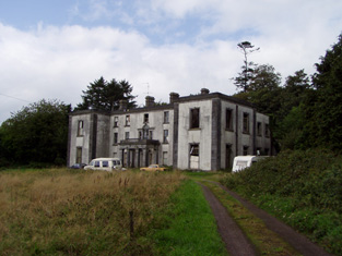
Moydilliga/Modeligo
Houses within 5km of this house
Displaying 17 houses.
Houses within 5km of Moydilliga/Modeligo
Displaying 17 houses.
| House name | Description | |
|---|---|---|
| Kilbarry (Castlelyons) | Hajba writes that a new house was built here in 1842 by the Wigmores. Robert Wigmore was resident in 1814, E[dward] Wigmore in 1837 and Henry Wigmore in the early 1850s when the buildings were valued at £23 and held in fee. In 1786, Wilson states that it was the residence of Hon. Mr. Moore. Later the home of the Kent and Waters families. Still extant and occupied. |

|
| Ballyglass/Ballyclough House | At the time of Griffith's Valuation Michael Cagney owned a house in the townland of Kilmagner valued at £24. Ballyglass House is marked on the first Ordnance Survey map in this townland. but the house at this location is named Ballyclough House on the 25-inch Ordnance map of the 1890s. Hajba identifies this house as Ballyclough House, Currabeha. Ballyclough was the residence of E. Creed in 1837. A house still exists at this location. | |
| Kilmurry | The house was built in the early 18th century and remained in the hands of the Grant family until sold to the Rosminian Order in the 1930s. In the 1940s the Irish Tourist Association surveyor was given to understand that the Grants still retained title to the property and were residing in South Africa. In the mid 19th century it was valued at £37 and held by Thomas St John Grant in fee. At the beginning of the 21st century this house was in a dilapidated state. |
|
| Marshtown/Marston | Home of Richard Henry Gumbleton in the early 19th century and at the time of Griffith's Valuation when the buildings were valued at £12. 10 shillings. Advertised for sale in June 1854. Hajba writes that the Orpens built a much large house on the demesne in the 1860s which was burnt some time later. In 1906 Basil Orpin occupied a house valued at £55 at Marshtown. Buildings still exist at this site. An earlier Marshtown House, previous home of the Gumbletons, was located over the border in county Waterford. | |
| Carrigeen Hall | In 1786, Wilson refers to "Carrygeen" as the seat of Mr. Peard. Hajba writes that this house was the home of Peard Harrison Peard, son of Richard Peard of Coole Abbey and father of Richard Frederick Peard of Belvidere and Henry Peard of Carrigeen. Later the home of the Green and O'Grady families, now demolished. | |
| Sun Lodge | Sun Lodge is marked on the first Ordnance Survey map and was occupied by Denis Hanan in the mid 19th century and held from Henry Peard. It was valued at £30+. Hanan's interest was advertised for sale in 1870. Hajba records various other occupants and this house is still occupied and well maintained. |
|
| Castleview | Castleview was the home of the Gumbleton family held from Henry Peard in the mid 19th century and valued at £68.15 shillings. The house remained in Gumbleton possession until the early 20th century but is now demolished. Bence Jones lists this house under the name Glynnatore and writes that it was built in 1791 by R. W. Gumbleton. In 1894 Slater notes Glenatore as the seat of Mrs. Gumbleton. | |
| Waterpark | Originally a Pyne residence which later passed through marriage to the Cavendishes. In 1786 Wlson refers to "the ruins of Water Park, the seat of the late Lord Chief Justice Pine". Hajba writes that other occupants were the Watkins and Drew families. There was no house of more than £2.10 shillings valuation in this townland, held by George Walker, at the time of Griffith's Valuation. | |
| Bride Park | Hajba writes that the Reverend Stephen Rolleston built this house in the 1770s. In 1814 it was inhabited by the Reverend Spread and in the mid 19th century by Thomas Power who held it from Mrs Elina Greaves and others. The buildings were valued at £20+. Bride Park remained the home of the Power family until the early 20th century. This house has recently been renovated and restored. |

|
| Carrigmore | Richard Power was resident here in 1814 and Edward Morragh in the mid 19th century. Morragh held the property from the Duke of Devonshire and the buildings were valued at £18+. Later the home of the Cronin family. Hajba writes that this house has been unoccupied since 1990. | |
| Thornhill | A Nason home, first occupied by John William Washington Nason. His widow Mrs Barbara Nason is recorded as resident at the time of Griffith's Valuation. Valued at £18.11 shillings the house was held from the Duke of Devonshire. The Nason family continued to live here until the mid 20th century. The house is still an occupied residence. | |
| Mogeely House | A house on the Devonshire estate, occupied by Charles H. Walsh in the mid 19th century and valued at £25.18 shillings. Later the home of the Des Barres and Kent families. Slater refers to it as the seat of Lt-Col. Des Barres in 1894. Still a family residence. It is labelled Mogeely Castle on the 1st edition Ordnance Survey map but as Mogeely House on the later editions, |
|
| Elgin Cottage | In 1851 this property was leased by Georgiana Gumbleton to Edmund Barry when it was valued at £10. It was built after the 1st edition Ordnance map and is labelled Elgin Cottage on the 25-inch edition of the 1890s. There is still an extant house at the site. | |
| Marshtown House | Held in fee by R.H. Gumbleton at the time of Griffith's Valuation, when it was valued at £8 10s. The property is labelled Marshtown House on the 1st editon Ordnance Map but is not labelled on the later 25-inch edition. Marston House (W950987), in the adjacent townland of Marshtown, is shown on the 25-inch map of the 1890s but there is no trace remaining. | |
| Cloonbeg | A property described as offices, the property of R.H. Gumbleton, was valued at £15 5s at the time of Griffith's Valuation. In 1906 this property was owned by Basil Orpin with a valuation of £16. Some of the buildings still remain at the site. | |
| Ballyduff Castle Farm | Described as Ballyduff Castle (in ruins) on the 1st edition Ordnance Survey map, these buildings were valued at £11 15s at the time of Griffith's Valuation. They were being leased by Edward Walsh from the Musgrave estate. The National Inventory of Architectural Heritage suggests the house was built c.1825. The ruined fortified house at the site dates from the early seventeenth century. |
|
| Mocollop Castle | Mocollop Castle was in ruins by the time of Griffith's Valuation, though buildings at the site were valued at £31. They were held in fee by Captain James Barry. In 1786, Wilson refers to it as the seat of Dr. Drew. In 1906 the buildings at this location were in the possession of Henry Drew, MD, and valued at £32. The National Inventory of Architectural Heritage reports that the buildings there were in ruins in the early part of the 21st century. |

|