Ballydivlin House
Houses within 10km of this house
Displaying 14 houses.
Houses within 10km of Ballydivlin House
Displaying 14 houses.
| House name | Description | |
|---|---|---|
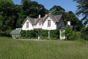
| Ballyrisode House | Richard B. Hungerford held this property in fee at the time of Griffith's Valuation, when it was valued at £16. In 1906 it was owned by Elizabeth Hungerford and valued at £15 10s. The National Inventory of Architectural Heritage states that the present house is of late nineteenth century date. In 2009 it was for sale. |
|
| Rockview | David Cagney was the lessor of several properties in Crookhaven at the time of Griffith's Valuation. One of these was Rockview, leased to Frederick Monks and valued at £11. In 1837 Lewis had noted Rockview as the seat of Florence McCarthy. It is not marked on the 25-inch Ordnance Survey map of the 1890s. | |
| Goleen House | At the time of Griffith's Valuation, Alicia Notter was leasing this property to Jeremiah McCarthy, when it was valued at £7. In 1837 Lewis had noted it as the seat of J. McCarthy. [Grid Reference is approximate] | |
| Crookhaven House | At the time of Griffith's Valuation, David Cagney was leasing this property to Isaac Notter, when it was valued at £11. Lewis noted Crookhaven House as the seat of R. Doe, in 1837. This property does not appear on the 25-inch Ordnance Survey map of the 1890s. | |
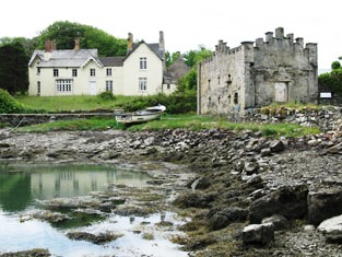
| Crookhaven Hotel | David Cagney was leasing a property described as a hotel to John O'Brien at the time of Griffith's Valuation. It was valued at £7 10s. Buildings are still extant at this site. | |
| Carrigmanus House | Rev. Thomas O'Grady was leasing this property to Nathaniel Lemon (?) at the time of Griffith's Valuation, when it was valued at £12. There is still a house at the site. |
|
| Rock Island House | At the time of Griffith's Valuation, Thomas Notter held this property in fee when it was valued at £16 10s. In 1837 Lewis recorded it as the seat of J. Notter. Leet refers to Rock-Island as the residence of Henry Alleyn in 1814. It is still extant. |
|
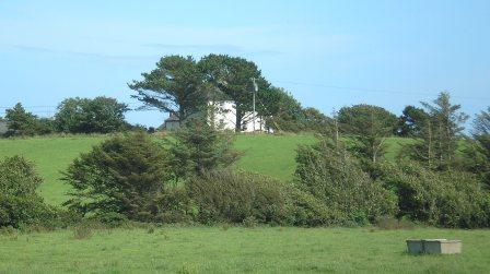
| Toormore Cottage | Rev. William Fisher held this property in fee at the time of Griffith's Valuation, when it was valued at £12 10s. Lewis had recorded it as the seat of J. Baillie in 1837. | |
| Ardmanagh House | John Limerick was leasing this property to Thomas Nicholls at the time of Griffith's Valuation when it was valued at £10. Substantial modern building has taken place in the area. | |
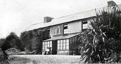
| Rock Cottage (Skull) | James O'Callaghan was leasing Rock Cottage from the Earl of Bandon's estate at the time of Griffith's Valuation, when it was valued at £11. In 1837 Lewis had recorded it as the residence of J. O'Callaghan. James O'Callaghan owned over 450 acres in the area in the 1870s. Operated as a guesthouse in the later twentieth century and offered for sale in 2009. |

|
| Seafort | Mountifort Longfield was leasing this property to Stephen Browne at the time of Griffith's Valuation, when it was valued at £9 10s. May possibly have been owned by William Hull in 1814. In 1894, Slater refers to it as a residence of Mountifort Longfield. The house is still extant, together with extensive farm buildings. |

|
| Leamcon House | At the time of Griffith's Valuation, William Hull held this property in fee when it was valued at £20. It had also been noted by Lewis as the seat of the Hull family in 1837. In 1814 it was the residence of R.E. Hull. The 1st-edition Ordnance Map also indicates the site of Old Leamcon House as well as a defensive battery. Leamcon House is still extant and occupied. |
|
| Lissacaha Cottage | Phillip Somerville held this property in fee at the time of Griffith's Valuation, when it was valued at £12 10s. It is labelled "Lissacaha Cottage" on the 1st edition Ordnance Map but has become "Prairie Cottage" on the later 25-inch map. In 1906 it was owned by Thomas Phillip Somerville and valued at £15 5s. It is no longer extant. | |
| Lowertown Corn Stores | Daniel McCarthy was leasing a building described as "corn stores" from the Hull estate at the time of Griffith's Valuation, when it was valued at £10. It is not evident on the 25-inch map of the 1890s. |