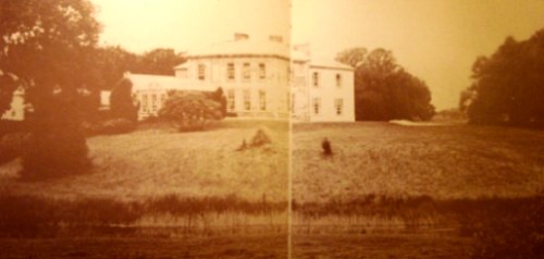
Ballynakill
Houses within 5km of this house
Displaying 12 houses.
Houses within 5km of Ballynakill
Displaying 12 houses.
| House name | Description | |
|---|---|---|
| Finniterstown | Mr Edmund Hogan was resident at Finniterstown in 1814. The Ordnance Survey Field Name book records the building of a 2 storey house at Finneterstown in 1833 and that it was occupied by William Fosberry circas 1840. Located on the St Leger estate this house was occupied by Frederick Maunsell in the early 1850s and was valued at £11. | |
| Ballyknockane | The home of the Scanlan family from at least 1814 when Michael Scanlan was resident. Occupied by William Scanlan at the time of Griffith's Valuation, held by him in fee and valued at £25+. In 1906 William Scanlan held 145 acres of untenanted land and a mansion valued at £22 at Ballyknockane. Residence of Miss Reynolds in 1944. | |
| Ballynahaha | The residence of Mathew Scanlan circa 1840. Located on the Scanlan estate in the mid 19th century, occupied by David Bennett and valued at £11. | |
| Kilbeg Lodge | The seat of John Scanlan circa 1840 and of Sarah Scanlan in the early 1850s, held from William Scanlan and valued at £14. In 1906 occupied by William Scanlan and valued at £10. | |
| Castleroberts | Occupied by Michael Cantlow [Cantillon] in 1814 and by John Heffernan Cantillon at the time of Griffith's Valuation and held from Edward B. Hartopp. The buildings were valued at £13+. A farmyard is visible at the site now. | |
| Carass House | Caherass/Carass House was the seat of the Roche family from the early 19th century. The family had a large flour mill in the townland of Caherass and the house was situated closeby but in the next townland. At the time of Griffith's Valuation Sir David Roche held the house and 235 acres in Ballouragan from Messrs Barrington and Delmege. In 1894 it was the seat of Sir David V. Roche. In 1943 the Irish Tourist Association surveyor wrote that the house was accidentally destroyed by fire "many years ago". | |
| Carass Court | ''Burke's Irish Family Records'' states that Jeffrey Browning purchased Carass Court, from Lord Carbery. Leet records Jeffrey Browning as the proprietor of Carass Park in 1814. Jeffrey/Geoffrey Browning was married to Frances, sister of Sir David Roche, 1st Baronet. By the time of Griffith's Valuation Thomas Wise Browning was the occupier and he held the property, valued at £50, from Sir David Roche. The Brownings were still resident at Carass Court in the 1940s but the house was later demolished. |
|
| Croom House | Croom House was the home of the Lyons family in the 18th and 19th centuries. The house of James D. Lyons was valued at £48 in the early 1850s and he had a flour mill valued at £75 closeby. He held the property from John Croker. Described in 1943 by the Irish Tourist Association surveyor as a beautiful mansion on the left bank of the Maigue river, it was then in use as a military post. The house is still extant and occupied. |

|
| Croom Castle | Originally a Fitzgerald Castle, subsequently granted to the Duke of Richmond who sold it to John Croker in 1721. Reverend Fitzgerald writes that Croker was agent to the Duke. A residence was built with some of the stone from the old castle. Situated on the outskirts of the town of Croom this house was occupied by Samuel A. Dickson in the mid 19th century who held it from the Crokers. The buildings were valued at £30. Sold in the late 1880s to the Lyons family and bought by Michael Corry in 1936. Now functions as self catering accommodation. see http://www.croomcastle.com/history.html |

|
| Dunnaman | Matthew O'Flaherty held buildings valued at £13+ and 219 acres from James D. Lyons at the time of Griffith's Valuation. Grid Reference is approximate. | |
| Carrigeen | John Christy held a house valued at £21 and 513 acres at Carrigeen from the Earl of Dunraven at the time of Griffith's Valuation. A modern farm is extant at the site now. | |
| Dollas Upper | Mary Blake occupied a house valued at £12+ and 48 acres on the Langford estate at the time of Griffith's Valuation. This property is labelled Dollas House on the Ordnance Survey map published in 1942. Unroofed buildings are still extant at the site. |