Castle Gore
Houses within 5km of this house
Displaying 11 houses.
Houses within 5km of Castle Gore
Displaying 11 houses.
| House name | Description | |
|---|---|---|
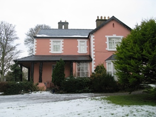
| Croftonpark | ||
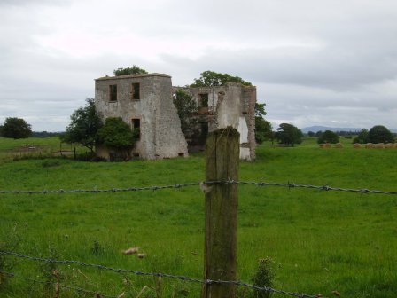
| Deel Castle | James Cuff, Lord Tyrawley, built a house beside the Old Bourke Castle in 1791. It is labelled Deel Castle on 1st edition Ordnance survey map but as Castle Gore on the later 25-inch edition The house was burnt in 1922 and not rebuilt. |
|
| Croftonpark | Described in the Ordnance Survey Name Books as a 'neat house', built in 1784 and occupied by Hugh Dane [Deane]. Robert Hunter lived there at the time of Griffith's Valuation and Patrick Ruane refers to the recent death of James Hunter, the owner of the house in the early 1990s. The house is still extant but no longer in use. |
|
| Carrowmore/Carramore | Wilson notes "Keromore" as the seat of Mr. Vaughan in 1786. The Ordnance Survey Name Books refer to the house as "a modern structure built in 1819". At the time of Griffith's Valuation it was held in fee by Captain O. Jackson and valued at £30. The Irish Tourist Association File states it was a guest house in the 1940s run by Mrs Reid. Bence Jones writes that it is now a ruin. | |
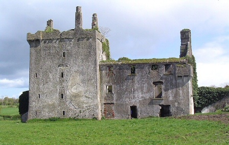
| Rappa Castle | An old Bourke castle, granted to a Cromwellian soldier named Crofton. It passed into Knox ownership through marriage and was the seat of this influential branch of the Knox family throughout the 18th and 19th centuries. In 1786 Wilson refers to it as "the pleasant seat of Mr. Knox". At the time of Griffith's Valuation it was held in fee by Annesley Knox and valued at £30. Slater notes it as the seat of Captain Annesley Knox in 1894. Occupied by the Knox family until the early 20th century, the house is now a ruin. |
|
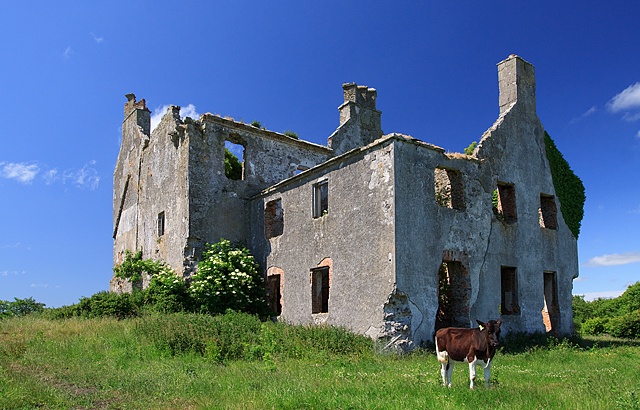
| Netley House | The home of Henry William Knox, fourth son of Francis Knox of Rappa, occupied by Richard Burke at the time of Griffith's Valuation when the house was valued at £30.. The house is now a ruin. |
|
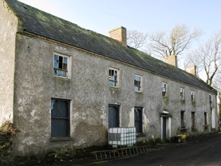
| Abbeytown | The original historical abbey buildings in this townland are described as 'in ruins' at the time of the first Ordnance Survey. It was formerly the residence of a Mr Crofton but was then occupied by a caretaker for the Orme family. Abbeytown House is shown a litte to the north on the later 25-inch map of the 1890s. The property was bought by Anthony Carolan of Crossmolina at the sale in 1852 and the house was later lived in by the parish priest. Abbeytown is still extant and occupied. |
|
| Gortnaraby/Gortnor Abbey | Ruane dates this house to the mid 18th century.In 1786 Wilson refers to it as the seat of Mr. Ormsby. At the time of Griffith's Valuation, it was leased from John Ormsby by an individual named Connop and valued at £25. In 1916 it was taken over by the Order of Jesus and Mary and now functions as a secondary school. |

|
| Knockglass | The main residence of the Paget family in the 19th century. Afterwards it passed into the possession of Patrick Rowe and later served as the home of the Church of Ireland Bishop of Tuam, Achonry and Killala. In 2011 it was offered for sale. |

|
| Mullenmore | In 1786, Wilson refers to Mullennore as the seat of Mr. Cormack, "pleasantly situated on the edge of Lough Conn". The townland was in the ownership of the Palmer estate at the time of Griffith's Valuation and there was no substantial house there. | |
| Carnisk | John Sproule was leasing this property from Sir James Stewart's estate at the time of Griffiths Valuation in the 1850s, when it was valued at £18. This appears to be the house labelled Carnisk on the 25-inch Ordnance Survey map of the early twentieth century. An earlier house, shown on the 1st edition Ordnance Survey map, was located nearby at C209209. A large farming complex exists at the Carnisk site now. |