Tooreen
Houses within 5km of this house
Displaying 18 houses.
Houses within 5km of Tooreen
Displaying 18 houses.
| House name | Description | |
|---|---|---|
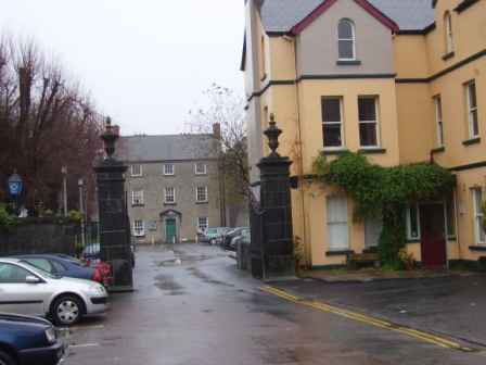
| Abbeyfield | A house in the town of Ennis, named Abbeyfield on the first Ordnance Survey map and Abbeyville by Samuel Lewis. In 1786 Wilson mentions that Lord Chief Justice Paterson had a residence in Ennis town. By the early 19th century it was being leased to Thomas Crowe. At the time of Griffith's Valuation the house was valued at £44 and was occupied by Wainwright Crowe who held it from Marcus Patterson. In the late 20th century it was used as a Garda station. |
|
| Stamer Park | A home of the Stamer family in the 18th century which was occupied by Daniel Finucane, Secretary to the Clare Grand Jury, by the beginning of the 19th century. Daniel's son Michael was resident in 1837. By 1860 Captain William Stacpoole who was elected Member of Parliament for Ennis was living in the house. The house is still extant. |
|
| Clonroad | A 17th century house in the possession of the Gore family from 1712 until 1852. The house was close to the River Fergus and had a brewery beside it. At the time of Griffith's Valuation the Gores were leasing the house and brewery to William Digges and the house was occupied by Henry Greene. In the 20th century the house which was rebuilt and extended in the mid 19th century belonged to the Knox and Merry families. | |
| Lifford House | Weir writes that in 1722 Francis Gore leased Lifford to Richard England. Patrick England was High Sheriff of the county in 1749. In 1786 Wilson refers to Lifford as the seat of Mr. England. By the early 19th century the Right Honourable Matthias Finucane was resident at Lifford House. Honoria Slattery, the common law wife, of Andrew Finucane, son of Matthias, occupied the house at the time of Griffith's Valuation. It was valued at £20 and was held from Sir Richard England. Weir writes that the house was demolished in 1965. | |
| Cranagher | Originally a Bindon home this property passed to the Blood family through a marriage in the 1770s. In 1814 it was occupied by Mr James Kerin and in the mid 19th century by Giles Darcy who held it from William Blood. The house was valued at less than £2. There is a substanial house and demesne marked on the first Ordnance Survey map at Cranagher. Weir writes that a new house was started sometime in the 19th century a short distance from the original but was abandoned before completion. General Sir Bindon Blood sold Cranagher in 1905. Some farm building and modern houses exist at the site now. | |
| Castletown House | The original house is now demolished and a 20th century house stands on the site close to an old Macnamara castle. The house was occupied by Francis Macnamara in 1814 and by Robert Malcolm in the mid 19th century who held it from Colonel George Wyndham. It was valued at £10. | |
| Moyriesk | Lewis writes that the finely wooded property of Lord Fitzgerald and Vesey was bought by his father from the Macnamaras. Occupied by George Sampson at the time of Griffith's Valuation, when it was valued at £35. Moyriesk was accidently burnt in 1875 though Slater still notes it as a property owned by them in 1894. |

|
| Ballyallia | An 18th century house, occupied by Andrew Kerin in 1814. It then became the home of Andrew Stacpoole and was owned by William Stacpoole in fee in the mid 19th century when the buildings, which included a house, steward's house, office and gate lodge, were valued at over £41. By the end of the 19th century the Vere O'Briens were living in the house. The house was considerably altered in the 1970s. | |
| Cloonteen | A house in the townland of Cloonteen is named Ballyallia on the first Ordnance Survey map. It was valued at £30 and was held by John Enright in fee at the time of Griffith's Valuation, now a ruin. Weir called this residence Templemaley House, the name by which it is labelled on the 25-inch map of the 1890s. | |
| Brookville | Occupied by Charles Janns in 1814, by J. Mahon in 1837 and by Luke Brady who held the property from Anne and Eliza Griffin at the time of Griffith's Valuation when it was valued at £16. | |
| Newpark | This house was built in the mid 18th century by the Hickman family. By 1814 it was been leased to the Mahon family who included James Patrick 'The O'Gorman Mahon', associate of Daniel O'Connell. Occupied by William Mahon who held it from Thomas Persse in the mid 19th century. Purchased by the Barron family in the early 20th century. The house now provides guest accommodation. see http://www.newparkhouse.com/newpage1.htm |
|
| Nutfield | A large three storey residence, Nutfield belonged to the Crowe family at the end of the 18th century and up to at least 1814 when it was the residence of Robert Crowe. Wilson refers to it and another house, which he calls Dromquin, as residences of the Crow family. He may be referring to Dromore House. By the mid 19th century Nutfield was the home of Sir Colman O'Loghlen who held it in fee. The buildings were valued at £40. The house is no longer extant. This house was also known as Drumconora. On the Taylor and Skinner map of 1778 it is named Nutgrove. | |
| Clooney House | Originally a 17th century house, the home of the Bindon family, it was burnt in the 19th century. Lewis refers to "Clonie, the demesne of Burton Bindon" in 1837. At the time of Griffith's Valuation the house was unoccupied and William S. Vesey Fitzgerald was the immediate lessor. Rebuilt in the latter half of the 19th century by Joseph Hall and his wife Ellen Bindon. The house was bought by the Tuckeys following the death of Joseph Hall in 1907, the land was divided in the 1920s and the house went to ruin. |
|
| Rosslevan | This house, close to the town of Ennis, was the residence of Francis Swyny in 1814. Rosslevan was occupied by Michael Kerin at the time of Griffith's Valuation. He held the property from the Reverend James Rynd. Rosslevan would appear to have been the home of the Davis family for some time in the 19th century. Members of the Davis family emigrated to Australia and called their new home Rosslevan. The sale rental of January 1875 records that the house had been "improved lately" and had eight bedrooms and three sitting rooms. Weir writes that Edward O'Brien, third son of the 14th Baron Inchiquin lived in the house before it was burnt in 1922. It is now a ruin. |
|
| Harmony House | The residence of Patrick Maxwell Cullinan on the River Fergus in Ennis in the 1870s. Local sources indicate he afterwards moved to Cragleigh House. | |
| Trinaderry | A house erected in the 1870s as the residence of Andrew Enright. It is labelled Trinaderry House on the 25-inch edition Ordnance Survey map of the 1890s. A house and farm are still extant at this site. | |
| Cappagh House | At the time of Griffith's Valuation occupied by John Curtin, valued at £12+ and held from the representatives of Stratford Kirwan. The house is no longer extant. | |
| Cappahard House | In 1786, Wilson refers to Cappaghard as the seat of Mr. Lukey. Two houses are shown in this townland at the time of the 1st Ordnance Survey, Cappahard House and Edenview House. By the 1890s the 25-inch map shows that Edenview has become known as Cappahard House and the original house has gone. This townland was the property of Thomas Persse at the time of Griffith's Valuation and included a herd's house valued at £4. In 1901 it was occupied by the Glynn family. |