Croftonpark
Houses within 5km of this house
Displaying 16 houses.
Houses within 5km of Croftonpark
Displaying 16 houses.
| House name | Description | |
|---|---|---|
| Quignashee | Edward Howley occupied a property valued at £5 at Quignashee, barony of Tireragh, as well as 300 acres, at the time of Griffith's Valuation. Since 1898 this townland has been located in county Mayo. A building remains at the site. | |
| Rahans | The home of the Atkinson family, Wilson notes in 1786 that it was the residence of Charles Atkinson and "very pleasantly situated". It was occupied by the rector of Crossmolina, the Reverend Edwin Stock, for a few years prior to 1815. Rahans was described in 1855 as "a comfortable dwelling house, in a fair state of repair" and occupied by Mrs Frances Atkinson. At the time of Griffith's Valuation it was the home of George Orme. In 1925 Adelaide R. Orme of New South Wales sold Rahans demesne to Patrick J. Ruttledge of Ballina for £3,000, [see Acc. 1165/8/11 National Archives.] It is no longer extant. | |
| Ardnaree Rectory | At the time of Griffith's Valuation Rev. Joseph Verscoyle was occupying the house at Glebe, parish of Kilmoremoy, valued at £30. This house is no longer extant. | |
| Downhill | The house at Downhill is recorded as being built by Mr. Brennan, Merchant, Ballina. It appears, from the Ordnance Survey Name Books, that the townland of Knockalyre or Downhill was part of the Gore estate in 1836. Dr. McHugh of Ballina also had an interest in the property which he was renting to Rev. Thomas Feeney in 1857. Colonel Knox Gore also had a mill complex in this townland which, at the time of Griffith's Valuation, he was leasing to William Symes. Downhill House became a hotel when it was purchased by the Moylett family in 1936. |
|
| Ardnaree Cottage | Ardnaree Cottage dates to at least the early eighteenth century and possibly earlier. It was part of the Gore estate. Wilson, writing in 1786, refers to "Mr. Jones' charming demesne". In 1837 it was the residence of Thomas Jones and in 1857 it was leased by Col Arthur Knox Gore to Anne Hearne when it was valued at £10. The National Inventory of Architectural Heritage notes it as an important component of the domestic built heritage of Ballina. It is still extant and well-maintained. |

|
| Deel Castle | James Cuff, Lord Tyrawley, built a house beside the Old Bourke Castle in 1791. It is labelled Deel Castle on 1st edition Ordnance survey map but as Castle Gore on the later 25-inch edition The house was burnt in 1922 and not rebuilt. |
|
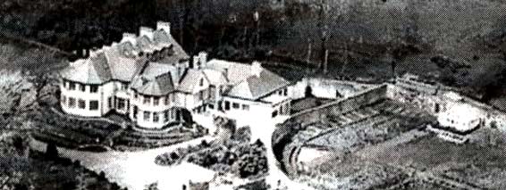
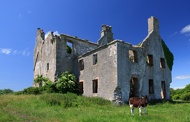
| Croftonpark | Described in the Ordnance Survey Name Books as a 'neat house', built in 1784 and occupied by Hugh Dane [Deane]. Robert Hunter lived there at the time of Griffith's Valuation and Patrick Ruane refers to the recent death of James Hunter, the owner of the house in the early 1990s. The house is still extant but no longer in use. |
|
| Castle Gore | The old Bourke Castle on the river Deel was granted to the Gores at the end of 17th century. They added a large wing to the old castle in the 18th century and renamed it Castle Gore. The castle along with other lands was leased to James Cuff, Lord Tyrawley towards the end of the 18th century. Wilson refers to it as "the pleasant old seat of the Earl of Arran, now occupied by Rt. Hon. James Cuffe" in 1786. Occupied by the Cuff's steward for part of the 19th century. At the time of Griffith's Valuation it was occupied by Captain St. George Cuffe and valued at £60. In 1894 Slater refers to it as a seat of the Earls of Arran though this may refer to the late eighteenth century house nearby. |

|
| Belleek Castle/Ballina House | Edward J Howley held Belleek Castle and demesne on a lease originally granted by James O'Hara 2nd Lord Tyrawley to Vaughan Jones for 999 years, dated 25 Mar 1739. He was residing at Belleek in the 1830s. The Castle was leased to the Pery family in the late 1860s. It is now known as Ballina House. |
|
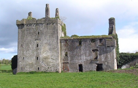
| Rappa Castle | An old Bourke castle, granted to a Cromwellian soldier named Crofton. It passed into Knox ownership through marriage and was the seat of this influential branch of the Knox family throughout the 18th and 19th centuries. In 1786 Wilson refers to it as "the pleasant seat of Mr. Knox". At the time of Griffith's Valuation it was held in fee by Annesley Knox and valued at £30. Slater notes it as the seat of Captain Annesley Knox in 1894. Occupied by the Knox family until the early 20th century, the house is now a ruin. |
|
| Belleek Manor/Abbey | Built in 1831 in the Gothic style. The seat of Maj.-Gen Saunders Knox-Gire in 1894. It was sold in 1940 to the Beckett family who resold it to Mayo County Council. It became a santorium but now functions as the hotel known as Belleek Castle. |
|
| Woodbine | A house belonging to the Gores, Earls of Arran, which was the residence of the Ham family until the 1860s, one of whom built the Upper Bridge over the River Moy in Ballina. The Hams subleased from the Jones family. The house was bought by Anne Elizabeth Jones in the early 1870s in trust for her son Henry Hastings Jones. The Jones family sold Woodbine to an American lady in 1939. It was offered for sale again in recent years. |
|
| Rathmeel | The representatives of William Ormsby were leasing a property valued at £12 at Rathmeel, barony of Tireragh, to Augustus Bolton at the time of Griffith's Valuation. Extensive modern development has taken place in this area. | |
| Quignamanger | Charles Craig was leasing a property valued at £6 at Quigamanger, barony of Tireragh, from Edward Howley at the time of Griffith's Valuation. Since 1898 this townland has been located in county Mayo. Modern housing exists in this location now. | |
| Quignalecka | At the time of Griffith's Valuation Rev. James Lindsay was leasing a property valued at £5 at Quignalecka, to Capt. William Wright. Since 1898 this townland has been part of county Mayo. | |
| Carnisk | John Sproule was leasing this property from Sir James Stewart's estate at the time of Griffiths Valuation in the 1850s, when it was valued at £18. This appears to be the house labelled Carnisk on the 25-inch Ordnance Survey map of the early twentieth century. An earlier house, shown on the 1st edition Ordnance Survey map, was located nearby at C209209. A large farming complex exists at the Carnisk site now. |