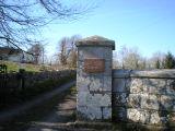
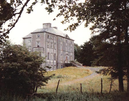
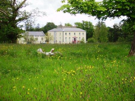
Killedan
Houses within 10km of this house
Displaying 17 houses.
Houses within 10km of Killedan
Displaying 17 houses.
| House name | Description | |
|---|---|---|
| Ashbrook | An early 18th century house, it was noted by Wilson as the seat of Mr. Moore in 1786. It was occupied by Michael Costello in 1814 and described as in a dilapidated state at the time of the first Ordnance Survey. The Irish Tourist Association file refers to a two-storey plain featured house with the ruins of a small private chapel closeby, which apparently fell into decay in the early 19th century. Some ruins remain at the site. | |
| Woodfield | At the time of Griffith's Valuation Francis R. O'Grady held the townland of Woodfield, which included an unoccupied house valued at £5. The house is labelled Woodfield House on both the 1st and 25-inch Ordnance Survey maps. Modern buildings exist at the site now though the ruins of some estate architecture is still visible. | |
| Carrowgowan | From at least 1814 the house was occupied by the Deanes who held it from Colonel McAlpine, who held from John Knox of Castlereagh. The house was described as in good repair, with offices, orchard and garden. Daniel H. Mellet occupied the house at the time of Griffith's Valuation. It is now demolished. | |
| Oldcastle | Built by the McJordans of Ballylahan in the late 18th century. Slater refers to it as the seat of John Bolingbroke in 1846. There are modern buildings at the site now. |
|
| Brabazon Park | Built by George Brabazon in 1777. In 1786 Wilson refers to it as "the fine seat of George Brabazon with beautiful demesnes".Slater refers to it as the seat of George Rutledge in 1846. It was held in fee by Captain Hugh Brabazon at the time of Griffith's Valuation, when it was valued at £30. Sold by the Congested District Board to the Sisters of Mercy circa 1920s, who ran a domestic economy school there for many years. It was demolished in the later twentieth century to make way for the building of a health care facility. Part of the demesne is now Swinford Golf Course and Community Sports Facility. |
|
| Thornhill | Home of Charles Burke Jordan in the 19th century. At the time of Griffith's Valuation, he was leasing this property to James Jordan when it was valued at £5. The building labelled Thornhill on the 1st edition Ordnance Survey map is not the same as that on the later 25-inch edition published in the 1890s. The latter is no longer extant but some buildings remain at the original site. | |
| Listrisnan House | This house was described as in 'good repair' at the time of the first Ordnance Survey in the 1830s. At the time of Griffith's Valuation, Joseph Jordan was leasing buildings valued at £2 in the townland of Listrisnan from Myles Jordan. A building still remains at the site. | |
| Midfield House | Occupied by Anthony Kelly in 1814 and by P. Kelly in 1837. There is no house with a significant valuation in this townland at the time of Griffith's Valuation. Farm buildings appear to occupy the site now. | |
| Longfield House | Occupied by Colonel Kelly in 1814 and by Mrs Kelly in the 1830s. A house valued at £4 in this townland in the 1850s was occupied by Andrew Walsh. It is now a ruin. | |
| Barleyhill | In 1786 Wilson noted Barleyhill as the seat of Mr. McManus. Ruane dates the house from about 1748 with alterations in the 1770s and 1790s. He states that the house and 170 acres were occupied by George Harkin at the time of Griffith's Valuation, however the Valuation records Bernard McManus as the occupier of the house valued at £15. Quinn records that Bernard McManus had gone to live at Brownstown in 1856. The Aitken family have lived at Barleyhill for over a hundred years. |
|
| Bellavary | Charles Goodwin lived in the house in the late 1830s. The Landed Estates' Court rental records that Bellavary House was leased to Standish O'Grady McDermott by William Malley on 10 Feb 1859 for 21 years. It later became a Royal Irish Constabulary barracks and burned down in 1920. | |
| Faheens | An O'Donnell residence in the 1830s. No house with a substantial valuation exists in the townland by the time of Griffith's Valuation. | |
| Newcastle | Newcastle was the home of Andrew Clarke O'Malley, son of George O'Malley of Spencer Park. Following the death of Andrew's son, Owen Bingham Manners O'Malley, in 1886, Newcastle became the property of his sister, Elizabeth Brewster. Count Manus O'Donel, a Major General in the Austrian Service, lived at Newcastle in the late 18th century. In 1786 Wilson refers to it as the seat of General O'Donnell. Occupied by David Ruttledge in 1814 and by Jacob Beckett at the beginning of the 20th century. Only a portion of the original building is now extant. |
|
| Ballinamore | This house was the home of the Ormsby family in the 18th and 19th centuries. It was held in fee by Anthony Ormsby at the time of Griffith's Valuation, when it was valued at £40. In 1786 Wilson refers to it as " the beautiful seat of Thomas Ormsby". In 1938 the Ormsbys sold Ballinamore to a Scottish order of nuns, the Order of St John, who used the house as a school. The building was donated to Western Care in the 1970s. It now functions as a nursing home. |
|
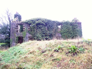
| Oxford | The home of members of the Joyce family in the late 18th and early 19th centuries, later held by the Tuohys in fee. In 1786 Wilson refers to it as the seat of "Mr. Joice". The house and over 740 acres held in fee by Martin Joyes were advertised for sale in the ''The Telegraph'' [Connaught Telegraph] of 13 July 1831. The original house is now a ruin. |
|
| Ballylahan | A property held by Pat McLaughlin from Sir William H Palmer in the early 19th century and by the Atkinsons at the time of Griffith's Valuation. Quinn writes that it was repossessed at the time of the expiration of their lease. It was a ruin by the publication of the 25-inch Ordnance Survey map of the 1890s. | |
| Liscottle | Home of the Horkan family in the second half of the 19th century. It was leased by George "Harkan" from Robert Ruttledge at the time of Griffith's Valuation when the house was valued at £2. It is labelled Liscottle House on the 25-inch Ordnance Survey map of the 1890s. Liscottle is no longer extant. |