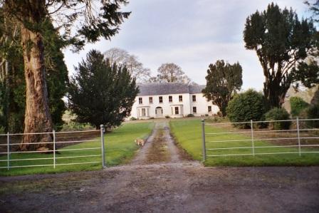
Beech Abbey
Houses within 5km of this house
Displaying 12 houses.
Houses within 5km of Beech Abbey
Displaying 12 houses.
| House name | Description | |
|---|---|---|
| Killukin Glebe/Killukin House | At the time of Griffith's Valuation, Archdeacon Henry Irwin was occupying the Glebe House in the parish of Killukin, valued at £11. This property is labelled Killukin House on the 25-inch Ordnance survey map of the 1890s. A house is still extant at the site. | |
| Danesfort (Roscommon) | At the time of Griffith's Valuation, William Roycroft was leasing the house at Danesfort, valued at £12, from Miss M. O'Connor. In 1814 it was recorded as the seat of Gilbert Roycroft. Lewis also describes "Deansfort" as the seat of the Roycroft family in 1837. Keenehan and others state that the Roycroft house was demolished c.1890 and another house constructed on the site by the Duignan family. | |
| Carrowreagh | Richard O'Farrell Caddell was leasing a "herd's" house valued at £8, together with over 350 acres, at Carrowreagh, barony of Boyle, to Thomas Boylan, at the time of Griffith's Valuation. A house and farm are still extant at the site. Patrick Fox was leasing a mill property from the Caddell estate in the same townland. Some stone buildings remain at the site though the mill was described as "in ruins" on the 25-inch Ordnance Survey map of the 1890s. | |
| Finnor House | At the time of Griffith's Valuation, Richard O'Farrell Caddell was leasing a house valued at £8, at Finnor, barony of Boyle, to Michael Barrett. It s labelled "Finnor House" on the 25-inch Ordnance Survey map of the 1890s and a house still exists at the site. | |
| Ryefield | At the time of Griffith's Valuation Andrew Cummins was leasing a house at Ryefield valued at £17 to John Dowd. It was occupied by John Cummins, agent to Nicholas Cummins at the time of the first Ordnance Survey. | |
| Fortview | At the time of Griffith's Valuation occupied by Erasmus Lloyd who held it from William Lloyd. This house is labelled Fortview on the 25-inch edition map of the 1890s. A house is still extant at the site. | |
| Ashfort House | The home of John Lawder in 1814. Occupied by Hubert K. Waldron in 1837. At the time of Griffith's Valuation occupied by John Hamilton and held from Thomas Goff. Farm buildings exist at the site now. There was a second smaller house known as Ashfort Vale in the same demesne grounds. It is no longer extant. | |
| Rockville | Home of the Lloyd family in the 18th and 19th centuries. Valued at £45 in the 1850s. Sold in 1917 to George Frayne of Ballaghderreen. Demolished in the second half of the 20th century. |

|
| Rush Hill | Home of the Devenish family in the 18th and 19th centuries, held from Sir Gilbert King. Funding received from the Heritage Council in 2005 for the restoration of this house. http://www.iol.ie/~oldbuilders/oldbuilders/rushhill/rushhill_01.htm. A detailed history and account of ongoing improvements to Rush Hill can be found at the blog www.irishaesthete.com tagged as Rush Hill. |
|
| Lissadorn | Lissadorn was a Crofton home from the mid 17th century. It became a Lloyd home in the 18th century following the marriage of Catherine Crofton and John Yeadon Lloyd in 1786. By 1814 Joseph Healy was living at Lisadurn. Burke's ''Landed Gentry of Ireland'' (1904) records the second son of Walter Balfe of Heathfield as John Balfe of Lissadorn. J. Balfe was residing at Lissadorn in 1837. At the time of Griffith's Valuation, Bernard Balfe held Lissadorn, valued at £20, from Viscount Lorton. It is no longer extant. On the first Ordnance Survey map (1838) the demesne included a smaller house named Ryefield. |
|
| Cloonfad | Home of the Browne family in the 18th and 19th centuries. | |
| Lisnanuran | Occupied by Robert Burns at the time of Griffith's Valuation and held from Arthur F. Lloyd. |