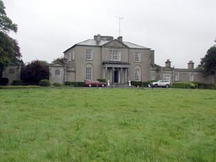
Roxborough
Houses within 5km of this house
Displaying 10 houses.
Houses within 5km of Roxborough
Displaying 10 houses.
| House name | Description | |
|---|---|---|
| Carrowroe Park | The home of the Goff family in the 19th century. Described by Lewis as a substantial and handsome mansion of limestone with a Doric portico, the residence of R. Goff. In the 1850s occupied by the Reverend William Battersby, who held the property from the Earl of Essex. Reverend Battersby was married to Mary Maud Caulfield, a daughter of John Caulfield, Archdeacon of Kilmore. The house was valued at £65. By the 1870s the residence of John Burke and the seat of Lt-Col. Michael A. Burke in 1894. Still extant and offered for sale in 2008 (Irish Times, 5 June 2008). |
|
| Holywell | Originally a Gunning home that passed to the Blakeneys by marriage. In 1786 Wilson mentions it as the seat of Charles Blakeney. Occupied by C. W. Blakeney in 1837 and by Henry Smyth in the 1850s who held the property from John Goodall. The property is no longer extant. | |
| Essex Lawn | Built after the First Ordnance Survey on part of the estate of the Earl of Essex, this house was occupied by John Kelly in the 1850s when it was valued at £18 10s. It is still extant. |
|
| Derrane House | The home of the Corr family in the 19th century, Henry Corr is recorded as living at "Durham" in 1814. Henry "Gorr" was residing in a property here valued at £12 at the time of Griffith's Valuation. It is recorded as "Derrane House [in ruins]" on the 25-inch Ordnance Survey map of the 1890s and very little trace remains of it now. | |
| Drumdaff | Charles Croghan, a farmer, lived at Drumduff in 1749. Home of the Digby family in the 19th century. Held in fee by George Digby at the time of Griffith's Valuation when the buildings were valued at £17.It is still extant and maintained. |

|
| Carrowmore | Carrowmore was occupied by John Davis at the time of Griffith's Valuation, when it was valued at £8 and leased from the Gunning estate. It is labelled Carrowmore House on the 25-inch Ordnance Survey map of the 1890s. A house still exists at the site. | |
| Mullymucks/Fortview | Built post 1838, though the National Inventory of Architectural Heritage suggests it is a modified 18th century house. Occupied by Francis Lyng in the 1850s, when it was valued at £24. It is still extant and now known as Fortview House. |
|
| Munsborough House | Built post 1838 and occupied by Edward Pearse in the 1850s, when it was valued at £20. Extensive buildings are shown at the site on the 25-inch edition Ordnance Survey map of the 1890s, labelled Munsborough House. A house and large farm are still extant at the site. | |
| Ballybride | James O'Farrell was leasing over 180 acre and a herd's house from Louisa Pelly at Ballybride, barony of Roscommon, at the time of Griffith's Valuation. | |
| Durham Lodge | Elizabeth Sandys advertised for sale "Durham Lodge" and 39 acres in July 1854. The Sandys house was valued at £3 in the 1850s and in 1906. This house was held in fee by William "Sands" at the time of Griffith's Valuation. It is not named on the 1st edition Ordnance Survey map but is shown as Durham Lodge on subsequent editions. A farm is still extant at the site. |