Portobello
Houses within 5km of this house
Displaying 10 houses.
Houses within 5km of Portobello
Displaying 10 houses.
| House name | Description | |
|---|---|---|
| Cavelawn | Guy Lloyd was leasing a house at Faus valued at £10 to James Acheson at the time of Griffith's Valuation. The house at this site is labelled Cavelawn on the 25-inch Ordnance Survey map of the 1890s. A house is still extant at the site. | |
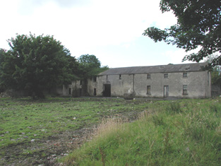
| Croghan | At the time of Griffith's Valuation, Guy Lloyd was the occupier of the house at Croghan, valued at £40. In 1749 the Census of Elphin shows that J. Lloyd, spinster, lived there. Wilson also notes it as a seat of the Lloyd family in 1786. Croghan House is no longer extant but an extensive range of outbuildings remains. |
|
| Cloverhill | At the time of Griffith's Valuation, Thomas Cox was leasing a house from the Lloyd estate at Bunreagh, barony of Boyle, valued at £10 . This property is labelled Cloverhill on the 25-inch map of the 1890s. A house and substantial farn are still extant at the site. | |
| Hermitage | Lewis records the Lloyd family occupying a second house called Hermitage also located in the townland of Croghan. Buildings still exist at the site. | |
| Finnor House | At the time of Griffith's Valuation, Richard O'Farrell Caddell was leasing a house valued at £8, at Finnor, barony of Boyle, to Michael Barrett. It s labelled "Finnor House" on the 25-inch Ordnance Survey map of the 1890s and a house still exists at the site. | |
| Dooneen | The representatives of Daniel Ferrall were leasing a property valued at £5 together with 200 acres to John Sharkey at the time of Griffith's Valuation. A farm is still extant at this location. | |
| Scor More | At the time of Griffith's Valuation, Scor More was leased to Patrick Beirne by the Lloyd estate and was valued at £3. 100 acres was also leased. This house is not shown on the 1st edition of the OS map. | |
| Ryefield | At the time of Griffith's Valuation Andrew Cummins was leasing a house at Ryefield valued at £17 to John Dowd. It was occupied by John Cummins, agent to Nicholas Cummins at the time of the first Ordnance Survey. | |
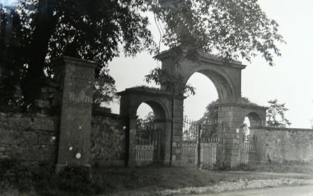
| Lissadorn | Lissadorn was a Crofton home from the mid 17th century. It became a Lloyd home in the 18th century following the marriage of Catherine Crofton and John Yeadon Lloyd in 1786. By 1814 Joseph Healy was living at Lisadurn. Burke's ''Landed Gentry of Ireland'' (1904) records the second son of Walter Balfe of Heathfield as John Balfe of Lissadorn. J. Balfe was residing at Lissadorn in 1837. At the time of Griffith's Valuation, Bernard Balfe held Lissadorn, valued at £20, from Viscount Lorton. It is no longer extant. On the first Ordnance Survey map (1838) the demesne included a smaller house named Ryefield. |
|
| The Palace | Built as the residence of the Protestant Bishop of Elphin in 1685 from money bequeathed by Bishop Hudson. Altered in the mid 18th century and remained as the Bishop's residence until 1845. At the time of Griffith's Valuation the home of Arthur O'Conor, younger brother of Denis O'Conor of Mount Druid. Valued then at £55 and held from the Ecclesiastical Commissioners. Accidentally burnt in 1911, the main block is now demolished. |