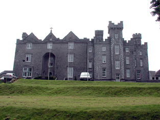
Castlecoote
Houses within 5km of this house
Displaying 15 houses.
Houses within 5km of Castlecoote
Displaying 15 houses.
| House name | Description | |
|---|---|---|
| Dunamon | A tower house with 18th and 19th century additions, In 1786 Wilson refers to Dunamon, the seat of Mr. Caulfeild, as "a fine old castle". Occupied by John Shiel, leasing from the Caulfeild estate at the time of Griffith's Valution, when it was valued at £35. In 1894 Slater refers to it as a residence of St.Geroge Francis Caulfeild. Bought by the Divine Word Missionaries from the Land Commission in 1939 and now in use as a care centre. |
|
| Emlaghkeadew | At the time of Griffith's Valuation this house was ccupied by Louis Ormsby when it was valued at almost £10. It is no longer extant and a modern house exists at the site now. | |
| Castlestrange | Named after the L'Estrange family who held the land and castle in the late 16th century, Castlestrange appears to have belonged to the Gunning family early in the 18th century. A house was built by the Mitchell family in the 18th century which at the time of Griffith's Valuation was valued at £47. In 1894 the residence of James Mulry and occupied by Thomas Mulry in 1906. The original house, coach house and stables are now in ruins but other outbuildings have been converted into a home. |

|
| Coolmeen | Referred to as a herd' s house at the time of Griffith's Valuation when it was occupied by William Harrison who held it from Patrick Curtis. The house now extant at the site is not the original one. |
|
| Mount Prospect | This house was the residence of John Browne in 1814. Recorded as the seat of Mr Fallon at the time of the first Ordnance Survey in the 1830s but in ruins by the mid 1850s. though a small portion of the house is labelled Mount Prospect on the 25-inch Ordnance Survey map of the 1890s. Small fragments of the building remain at the site. | |
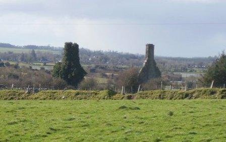
| Tobervaddy | The Ordnance Survey Field Name Books record the ruins of an old castle. The Discovery map mark a fortified house. A branch of the Ormsby family resided at Tobervaddy in the 18th century. and Wilson, writing in 1786 refers to Tobervaddy as the seat of Mr. Ormsby. Robert Irwin held the townland at the time of Griffith's Valuation. |
|
| Cloverhill | Latouche esquire lived at Cloverhill in 1778 and Wilson refers to it as the seat of John La Touche in 1786. The residence of Thomas Hurst in 1814 and of John Hurst in 1837. Occupied by Edward Jones, who held from Thomas Booth, at the time of Griffith's Valuation. The main road has been directed through the site and only a few ruins remain. | |
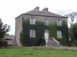
| Emlaghroyin | Built circa 1770, occupied by McDermot esquire in 1778 and also noted as the residence of Thomas McDermott by Wilson in 1786. The seat of Oliver Armstrong at the time of Griffith's Valuation, held from St George Caulfeild and valued at £30. This house is still extant. |
|
| Rushfield House | Occupied by Patrick Shiel at the time of Griffith's Valuation .Labelled Rushfield House on the 25-inch Ordnance Survey map of the 1890s. There is still a house at the site. | |
| Kilbegnet House | Occupied by John Shiel at the time of Griffith's Valuation and valued at £25. The property is labelled Kilbegnet House on the 25-inch edition of the Ordnance Survey map. A house is still extant at the site. | |
| Temp House | A house called Tempe was occupied by Charles O'Connor in 1814. IN the 1850s it was leased by Tobias Kelly from Catherine Mennons and valued at £13. A house is still extant at the site. | |
| Church Park | Church Park was occupied by Benjamin Reeves in 1814. It is shown on the First edition Ordnance Survey map of the 1840s but is not labelled on the later 25-inch edition of the 1890s. The house is no longer extant but entrance gates are still visible. | |
| Rockfield | Another Mitchell house in the townland of Castlestrange, occupied by D. Merry in 1837 and by David Wakefield in the 1850s. It is not shown on the 25-inch Ordnance Survey map of the 1890s. Rockfield was the home of Christopher and Mary Anne Irwin in 1749. | |
| Ardmore (Dunamon) | In 1786 Wilson refers to Ardmore as the seat of Mr. Croaghan. By the 1830s an extensive demesne is shown in the area but no house is visible. The townland is in the possession of St. George Caulfield of Dunamon by the time of Griffith's Valuation. | |
| Ballinturly | In 1786 Wilson refers to Ballinturly as the seat of Mr. Mitchell. By the time of Griffith's Valuation, this townland is part of the estate of Sir Charles Coote. John Brennan was leasing a house valued at almost £4 and 180 acres at the time. The buildings are not shown on the 25-inch Ordnance Survey map of the 1890s. |