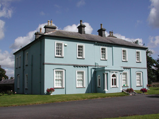
Carrowroe Park
Houses within 5km of this house
Displaying 14 houses.
Houses within 5km of Carrowroe Park
Displaying 14 houses.
| House name | Description | |
|---|---|---|
| Mote Park | The home of the Crofton family from the 17th century, valued at £140 in 1906. ''Saunders Newsletter'' dated 17 May 1865 refers to a fire at Mote Park which badly burnt the house. The house was demolished in the 1960s. Roscommon Golf Club occupies part of the original Mote Park demesne. |

|
| Ballymurray House | The Crofton family are originally recorded as 'of Ballymurray'. Ballymurray is the next townland east of Mote Demesne. A house at Ballymurray was occupied by Captain E. W. Kelly in 1837 and by Edmund Kelly in the 1850s, who held the house, valued at £9, from the representatives of James Daly. William Curtis was residing in Ballymurray in the 1870s. The property is labelled "Balymurray House" on the 25-inch Ordnance Survey map of the 1890s. It is no longer extant. | |
| Essex Lawn | Built after the First Ordnance Survey on part of the estate of the Earl of Essex, this house was occupied by John Kelly in the 1850s when it was valued at £18 10s. It is still extant. |
|
| Roxborough | Wilson, writing in 1786, refers to Roxborough as the seat of "Mr. Irvine". The residence of John Irwin in 1814 and of A. Brown in 1837. In the 1850s occupied by John Gaynor, when the house was valued at £20. The property is now a ruin. | |
| Lisbride | Occupied by John B. Purdon in 1814 and in 1822 by Arthur Browne. Patrick Duignan was resident at the time of Griffith's Valuation, when the house was valued at £12. A house still exists at the site. | |
| Kilteeven House | Still occupied by the Mapothers in 1906, when the house was valued at £20. Some ruined buildings remain at this site. |
|
| Hazelbrook | The residence of the Reverend Oliver Carey in 1814 and in the 1830s of Robert Blakeney. At the time of Griffith's Valuation occupied by Joseph A. Holmes and in 1906 by the representatives of John Neilan. Still extant but not occupied. | |
| Ballymartinbeg | At the time of Griffith's Valuation Jane Plunket held the house, offices and cornmill valued at £16 from the representatives of Gunning Plunket. Occupied by Martin McDonnell in 1906 and valued at £11. A house at the site has been recently renovated. |
|
| Englishtown (Ballygalda House) | A Mitchell family home from the mid 18th century. Occupied by William N. Reynolds at the time of Griffith's Valuation who held from George G. Battersby. The house was valued at £4.It is labelled Englishtown on the 1st edtion Ordnance Survey map but as Ballygalda House on the later 25-inch edition. A house and substantial farm are still extant at the site. | |
| Carrowmore | Carrowmore was occupied by John Davis at the time of Griffith's Valuation, when it was valued at £8 and leased from the Gunning estate. It is labelled Carrowmore House on the 25-inch Ordnance Survey map of the 1890s. A house still exists at the site. | |
| Ballybride | James O'Farrell was leasing over 180 acre and a herd's house from Louisa Pelly at Ballybride, barony of Roscommon, at the time of Griffith's Valuation. | |
| Martinstown | In 1786 Wilson refers to Martin's-town as the seat of Mr. Davys. The residence of George Davis in 1814 and of Mr Davis in the 1830s, apparently held from the Digby family. By the time of Griffith's Valuation Ballymartinmore was in the possession of George Digby and a vacant house valued at £4 was held by Edward Flynn. The house is no longer extant. |

|
| Grove | This house, near Roscommon town, is named Bob's Grove on the Taylor and Skinner map, the residence of Ormsby esquire. Wilson also refers to it as the seat of Mr. Ormsby in 1786. Occupied by Christopher Davies in 1814. The house is labelled Grove on the1st and 25-inch edition Ordnance Survey maps. | |
| Durham Lodge | Elizabeth Sandys advertised for sale "Durham Lodge" and 39 acres in July 1854. The Sandys house was valued at £3 in the 1850s and in 1906. This house was held in fee by William "Sands" at the time of Griffith's Valuation. It is not named on the 1st edition Ordnance Survey map but is shown as Durham Lodge on subsequent editions. A farm is still extant at the site. |