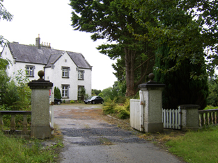
Nutfield House
Houses within 5km of this house
Displaying 22 houses.
Houses within 5km of Nutfield House
Displaying 22 houses.
| House name | Description | |
|---|---|---|
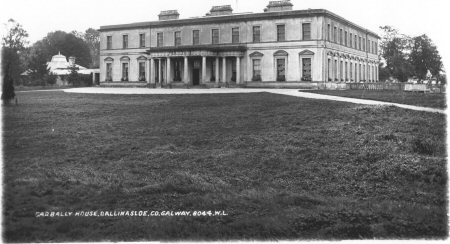
| Garbally Park | In 1783 Taylor and Skinner show Garbally as a seat of the Trench family. Wilson mentions Garbally , "the very fine seat of Willaim Power Keating Trench", in 1786. At the time of Griffith's Valuation it was the seat of the Earl of Clancarty and was valued at £150. It became St. Joseph's College, Garbally Park, in 1922 and has functioned as a school until very recently. It is still extant. |
|
| Fairfield House | Lewis records Fairfield as the residence of T. Wade in 1837. It is described in the Ordnance Survey Name books as "built on rising ground from which there is a good prospect". At the time of Griffith's Valuation the house was being leased by Thomas Wade from the Handy estate. In 1906 it was in the possession of Rochford Wade when it was valued at £23. Fairfield House is no longer extant and the demesne is the focus for a major sawmilling operation. |
|
| Northbrook Cottage | Lewis records Northbrook as the seat of J. North in 1837. The Ordnance Survey Name books note Major Warburton as the proprietor of the townland. The First Edition Ordnance map shows Northbrook Cottage. At the time of Griffith's Valuation, a house in progress in the townland was being leased by Joseph Denham from James McBride and was valued at £3 10s. This house is labelled Northbrook House on the 25-inch map of the 1890s. It is now a ruin. |
|
| Creggaun House | Bar Kelly was living at Cregan in 1749. At the time of the first Ordnance Survey it is mentioned as the home of Captain Masters. William Masters was leasing a house valued at £16 in Creggaun townland, parish of Ahascragh, from the Clonbrock estate at the time of Griffith's Valuation. This property is no longer extant. | |
| Annaghbeg House | John Moor lived at Anabeg in 1749 and in 1814 this was the residence of Edmund Moore. In the 1830s it is described by the Ordnance Survey Name Books as the residence of F. Grady and in bad repair. Charles Bailey was leasing the property at Annaghbeg, parish of Ahascragh, barony of Clonmacnowen from Hubert Moore at the time of Griffith's Valuation. Annaghbeg House is described as "in ruins" on the 1948 edition of the 6-inch OS map. Another house, known as Annaghbeg Cottage is located nearby at M823356. Buildings are still extant at the latter site. | |
| Kellysgrove | Wilson refers to Kellysgrove as the seat of Mr. Kelly in 1786. In 1837 Lewis recorded Kellysgrove as the seat of W. Kelly. The house was occupied by Charles Denis Kelly at the time of the Encumbered Estates court sale in December 1850. At the time of Griffith's Valuation, the house at Kellysgrove, parish of Clontuskert, valued at £20, was leased by Robert St. George from the Earl of Clancarty's estate. The original house is no longer extant. |
|
| Craig's Hotel | John H. Craig was leasing a property valued at £65 at Back, parish of Kilcloony, barony of Clonmacnowen from the Clancarty estate at the time of Griffith's Valuation. He was running this property as a hotel. In Slater's Commerical Directory, 1846, Craig's hotel was located on the Main Street in Ballinasloe. The Royal Mail car called there on its way from Galway to Dublin. | |
| Brackernagh Lodge | A house valued at £18 at Brackernagh, parish of Kilcloony, barony of Clonmacnowen, was being leased by the Clancarty estate to Miss L. Trench at the time of Griffith's Valuation. This is most likely the house which appears on the 6-inch OS map as Brackernagh Lodge. The National Inventory of Architectural Heritage notes that it was previously known as Mount Catherine. It is still extant and occupied. |
|
| Caher | Lewis records Caher as the seat of J. Dillon in 1837. The house at Caher, with a demesne, the property of James Dillon, were offered for sale in the Encumbered Estates court in July 1854. Samuel Wade was leasing a property valued at £17 at Caher, in the parish of Kilcloony, barony of Clonmacnowen, from the Clancarty estate at the time of Griffith's Valuation. The ruins of the house and stable block are still visible. |
|
| Cleaghmore | Andrew Montgomery was leasing a house valued at £13 from the Clancarty estate at Cleaghmore, parish of Kilcloony, barony of Clonmacnowen, at the time of Griffith's Valuation. | |
| Cleaghmore Villa | A vacant house, valued at £11 and part of the property of Norman Ashe, was located at Cleaghmore, parish of Kilcloony, barony of Clonmacnowen at the time of Griffith's Valuation. This is possibly the house shown on the 25-inch Ordnance Survey map of the 1890s as Cleaghmore Villa which is still extant. |
|
| Knockglass | Charles Masters was leasing buildings valued at £14 which included a mill at Knockglass, parish of Kilcloony, barony of Clonmacnowen, from the Ashe estate at the time of Griffith's Valuation. Builidings are still extant at the site. | |
| Cleaghmore B & C | At the time of Griffith's Valuation, the Clancarty estate was leasing two houses in this townland to members of the Le Poer Trench family, one (Cleaghmore B) valued at £23 and the other Cleaghmore C) at £21. They were leased by Mrs. Le Poer Trench and Robert Le Poer Trench respectively. | |
| Deerpark | At the time of Griffith's Valuation, James Horsman was leasing buildings valued at £28 which included a mill, at Deerpark, parish of Kilcloony, barony of Clonmacnowen, from the Clancarty estate. The property was in ruins by the 1890s. | |
| Mackney | In 1837 Lewis records Mackney as the seat of Archdeacon Trench. Henry Gascoyne was leasing a house valued at £36 from the Clancarty estate at Mackney, parish of Kilcloony, barony of Clonmacnowen, at the time of Griffith's Valuation. A second house in this townland, valued at £11, was leased to Thomas Gill. This may have been the property described on the 6-inch OS Map as Mackney Cottage. | |
| Perssepark | At the time of Griffith's Valuation, William Persse was leasing a house valued at £10 from Dudley Persse at Perssepark, parish of Kilcloony, barony of Clonmacnowen. Earlier, in 1837, Lewis recorded Perssepark as the residence of S. Masters. Now the site of modern industrial development. | |
| Beechlawn House (Kilcloony) | John Craig was leasing a house valued at £10 to Geoffrey Prendergast at Pollboy, parish of Kilcloony, at the time of Griffith's Valuation. On the 1st edition Ordnance Survey map the building at this site is labelled schoolhouse. However, a larger building of differing proportions is shown on the later 25-inch Map of the 1890s. The property at this site is named Beechlawn House by the National Inventory of Architectural Heritage. |
|
| Coololla/Coololah | At the time of Griffith's Valuation, George Crowe was leasing a property valued at almost £5 from the Handy estate at Coololla, barony of Kilconnell. Buildings appear at the site on the 1st-edition Ordnance Survey map but appear to be ruinous by the time of the 25-inch edition of the 1890s. | |
| Aughrim Castle | The 1st edition Ordnance Survey map indicates a house located a short distance to the north of the site of Aughrim Castle. Lewis records Aughrim Castle as the seat of R. Stanford in 1837. In 1786 Wilson mentions "Aghrim, the seat of the Rev. Mr. Ward". At the time of Griffith's Valuation, Robert Standord was leasing a property from the Handy estate, valued at £15, and which included a mill. It is no longer extant. | |
| Ashford Old House | At the time of Griffith's Valuation Joseph Sharpe was leasing a property from Dudley Persse, at Ashford, barony of Moycarn. It was accompanied by 350 acres and was valued at £5. In 1814 Leet records Ashford as the residence of John Maher. The 6" and 25"edition OS maps record this as "Ashford Old House". | |
| Tristaun | At the time of Griffith's Valuation, Simon Sellers was leasing a property valued at £8, including a mill, from the Earl of Clancarty's estate. | |
| Killure | Writing in 1786, Wilson refers to Killure as the seat of Mr. Dillon. He appears to be referring to either Killure Castle or a property associated with it. The castle is described as "in ruins" on the 1st edition Ordnance Survey map of 1842 and the ruin of the tower house is still visible. |