Fetherstonhaugh (Bracklyn)
A family from the north of England who settled in Ireland in the mid-seventeenth century. Various branches settled in different counties but mainly in County Westmeath. The senior branch descend from Cuthbert Fetherstonhaugh who settled at Dardistown, county Westmeath, about 1726. He married Mary Magan of the Umoe family. From their eldest son John descend the Fetherstonhaughs of Dardistown, Mosstown and Grouse Lodge. From their second son Thomas descend the Fetherstonhaughs of Bracklyn, Rockview and Griffinstown. At the time of Griffith’s Valuation (publ. 1854) the Bracklyn estate was in the parishes of Killagh, Killucan and Killulagh. At the same time the Fetherstonhaughs of Rockview held an estate in the parishes of Faughalstown, Killulagh, Mullingar and Churchtown, while Reverend John Fetherstonhaugh of Griffinstown owned an estate in the parish of Killucan. In the mid-1870s family members owned the following acreages in county Westmeath; Cecil Howard Digby Fetherstonhaugh of Bracklyn Castle 4,711 acres; the representatives of Reverend John Fetherstonhaugh of Griffinstown 2,234 acres; Richard Steele Fetherstonhaugh of Rockview, Killucan, 2,709 acres and 439 acres in County Meath; Rupert Pennefather Fetherstonhaugh of Balrath (Rockview family) 923 acres; William Fetherstonhaugh of Grouse Lodge 1,075 acres.
Houses
| Name | Townland | Civil Parish | PLU | DED | Barony | County | Map Ref | |
|---|---|---|---|---|---|---|---|---|
| Ballintober (Kilcumreragh) | Ballintober | Kilcumreragh | Athlone | Kilcumreragh 14 | Westmeath |
OSI Ref: N247426
OS Sheet: 31 Discovery map: 48 |
||
| Grouse Lodge | Coolatoor | Kilcumreragh | Athlone | Kilcumreragh 14 | Westmeath |
OSI Ref: N235441
OS Sheet: 31 Discovery map: 48 |

|
|
| Derrymore | Derrymore | Killucan | Mullingar | Derrymore 69 | Westmeath |
OSI Ref: N605507
OS Sheet: 28 Discovery map: 42 |
||
| Griffinstown | Griffinstown | Killucan | Mullingar | Griffinstown 73 | Westmeath |
OSI Ref: N565464
OS Sheet: 27 Discovery map: 49 |
|
|
| Dardistown | Dardistown | Killagh | Castletowndelvin | Killulagh 43 | Westmeath |
OSI Ref: N571582
OS Sheet: 13 Discovery map: 42 |
||
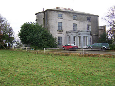
| Killua Castle | Killua | Killua | Castletowndelvin | Killua 36 | Westmeath |
OSI Ref: N664682
OS Sheet: 9 Discovery map: 42 |
|
|
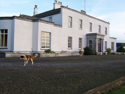
| Rockview House | Ballynacor | Killulagh | Castletowndelvin | Bracklin 40 | Westmeath |
OSI Ref: N583599
OS Sheet: 13 Discovery map: 42 |
|
|
| Sallyview | Bracklin | Killulagh | Castletowndelvin | Bracklin 40 | Westmeath |
OSI Ref: N628585
OS Sheet: 14 Discovery map: 42 |
||
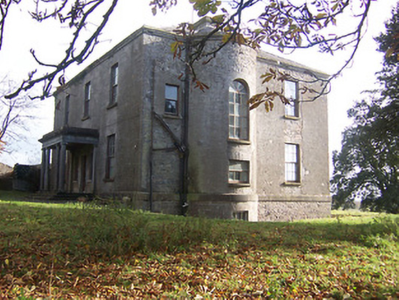
| Bracklyn House | Bracklin | Killulagh | Castletowndelvin | Bracklin 40 | Westmeath |
OSI Ref: N602582
OS Sheet: 14 Discovery map: 42 |
|
|
| Grange More House | Grange More | Killucan | Castletowndelvin | Riverdale 44 | Westmeath |
OSI Ref: N611543
OS Sheet: 21 Discovery map: 42 |
Map of Estate Houses
Click on the markers to view more details about each house.
Contemporary printed sources
- LEWIS, Samuel. ''A Topographical Dictionary of Ireland''. London: S. Lewis & Co., 1837: II, 79 (Ballintober)
- PARLIAMENTARY PAPERS. ''Return of owners of land of one acre and upwards, in the several counties .... in Ireland''. HC 1876, LXXX: 83
- HUSSEY DE BURGH, U. H. ''The Landowners of Ireland. An alphabetical list of the owners of estates of 500 acres or £500 valuation and upwards in Ireland''. Dublin: Hodges, Foster and Figgis, 1878. [available online at www.askaboutireland.ie] : 155
- ''GRIFFITH'S VALUATION OF IRELAND'[Primary Valuation of Tenements]', 1850-1858. : Athlone Union, 1 (Ballintober), 3 (Coolatoor)
- LEWIS, Samuel. ''A Topographical Dictionary of Ireland''. London: S. Lewis & Co., 1837: II, 79 (Ballintober and Grouse Lodge); II, 118 (Durdistown); II, 219 (Rockview and Bracklin); II, 156 (Derrymore and Griffinstown)
- LEET, Ambrose. ''A directory to the market towns, villages, gentlemen's seats, and other noted places in Ireland''. Dublin: Printed by B. Smith, 1814 : 76 (Bracklan Castle), 153 (Derrymore), 209 (Grangemore), 212 (Grouse Lodge)
- ''GRIFFITH'S VALUATION OF IRELAND'[Primary Valuation of Tenements]', 1850-1858. : Mullingar Union, 164 (Derrymore); 167 (Griffinstown)
- TAYLOR, George & SKINNER, Andrew. ''Maps of the Roads of Ireland, surveyed in 1777 and corrected down to 1783''. Facsimile of 2nd edition. Shannon: Irish University Press, 1969: 244 (Grangemore)