Urquhart
In 1846, Mary Isabella, only daughter and heir of William Urquhart of Craigston Castle, Aberdeen, married William Pollard of Castle Pollard, county Westmeath. His county Westmeath estate was located in the parishes of Lickbla, St Feighin’s but primarily in the parish of Rathgarve (10 townlands). He was MP for Westmeath from 1852 to 1857 and from 1859 to 1871. In the mid- 1870s his eldest son Walter William Dutton Pollard Urquhart owned 5,363 acres in the county and 558 acres in county Meath.
Associated Families
Houses
| Name | Townland | Civil Parish | PLU | DED | Barony | County | Map Ref | |
|---|---|---|---|---|---|---|---|---|
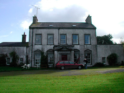
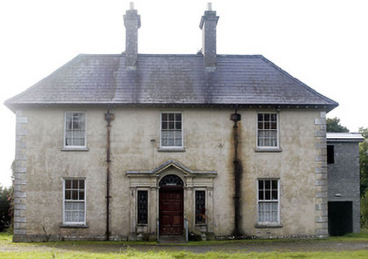
| Kinturk House | Kinturk Demesne | Rathgarve | Castletowndelvin | Kinturk | Westmeath |
OSI Ref: N463698
OS Sheet: 7 Discovery map: 41 |

|
|
| Benison Lodge | Benisonlodge or Bratty | St Feighins | Castletowndelvin | Faughalstown 27 | Westmeath |
OSI Ref: N468674
OS Sheet: 7 Discovery map: 41 |
||
| Loughpark | Loughpark | St Feighins | Castletowndelvin | Kinturk | Westmeath |
OSI Ref: N489689
OS Sheet: 7 Discovery map: 41 |
|
|
| Derrya | Derrya | Mayne | Granard | Coolure | Westmeath |
OSI Ref: N408693
OS Sheet: 7 Discovery map: 41 |
||
| Newcastle (Fore) | Newcastle | Lickbla | Granard | Glore | Westmeath |
OSI Ref: N416753
OS Sheet: 3 Discovery map: 41 |
||
| Castlecore/Castlecor House (Ballymahon) | Castlecore | Shrule | Ballymahon | Ballymahon | Longford |
OSI Ref: N137571
OS Sheet: 26 Discovery map: 41 |
|
Map of Estate Houses
Click on the markers to view more details about each house.
Archival sources
- Map of Newcastle and Doon. Co. Westmeath, the estate of William Pollard. Surveyed by Thomas William. Oblong folio sheet, Nov.1763. 16 J. 10 (3); National Library of Ireland
Contemporary printed sources
- ''GRIFFITH'S VALUATION OF IRELAND'[Primary Valuation of Tenements]', 1850-1858. : Granard Union p.15 (Newcastle), p.19 (Derrya)
- HUSSEY DE BURGH, U. H. ''The Landowners of Ireland. An alphabetical list of the owners of estates of 500 acres or £500 valuation and upwards in Ireland''. Dublin: Hodges, Foster and Figgis, 1878. [available online at www.askaboutireland.ie] : p.455
- PARLIAMENTARY PAPERS. ''Return of owners of land of one acre and upwards, in the several counties .... in Ireland''. HC 1876, LXXX: 87
- ''GRIFFITH'S VALUATION OF IRELAND'[Primary Valuation of Tenements]', 1850-1858. : Castletowndelvin Union, 52 (Kinturk Demesne); 62 (Benison Lodge); 71 (Loughpark)
- PARLIAMENTARY PAPERS. ''Return of Untenanted Lands in Rural Districts, Distinguishing Demesnes on Which There is a Mansion...'', HC 1906, c, 177: 365
Modern printed sources
- MCGUIRE, James & QUINN, James (eds.) ''Dictionary of Irish Biography''. Cambridge University Press, 2009: Hourican, Brigid. William Pollard Urquhart. https://www.dib.ie/biography/urquhart-william-pollard-a8768
- NATIONAL LIBRARY OF IRELAND. Reports on Private Collections: Ainsworth, J.F. Report on the Mooney and Dowdall Papers (from 1684), in the custody of Messrs. Nooney and Dowdall, solicitors, Mullingar, relating to the Pollard, Nugent and Brabazon families and to the lands in Cos. Westmeath and Cavan. No. 191.
- BURKE, Sir Bernard. ''A genealogical and heraldic history of the Landed Gentry of Ireland''. London: Harrison & Sons, 1904: 610-611
- ''Freeman's Journal'': 12 December 1855, p.3.