Malone (Westmeath)
The Malone family divided into two branches in the late seventeenth century, one residing at Ballynahown and the other at Baronstown. Baronstown was eventually inherited by Alice Malone (1767-1866) who married H O’Connor. Her estate was ‘In Chancery’ at the time of Griffith’s Valuation (publ. 1854). It was very extensive containing many townlands principally in the parishes of Castletownkindalen, Kilbixy and Kilmanevan. This estate was also among the principal lessors in the parish of Drumraney, barony of Kilkenny West and the parishes of Ballymore and Killare, barony of Rathconrath, Following her death it reverted to the senior branch of the family and John Malone of Baronstown is recorded as owning 12,554 acres in the 1870s. O’Brien writes that the Malones sold Ballynahown house and estate to Andrew Ennis in 1828. He gives extensive detail about this important Westmeath family in the entries in his book on Ballynahown, Baronstown and Shinglis.
Associated Families
Houses
| Name | Townland | Civil Parish | PLU | DED | Barony | County | Map Ref | |
|---|---|---|---|---|---|---|---|---|
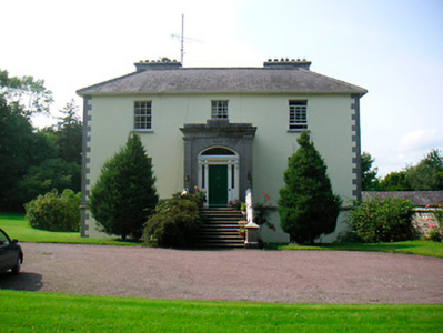
| Ballynahown | Ballynahown | Kilcleagh | Athlone | Castledaly 13 | Westmeath |
OSI Ref: N096338
OS Sheet: 35 Discovery map: 47 |
|
|
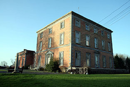
| Baronstown | Baronstown Demesne | Kilbixy | Mullingar | Kilbixy 55 | Westmeath |
OSI Ref: N328623
OS Sheet: 11 Discovery map: 47 |
|
|
| Oran Vale | Cumminstown | Kilbixy | Mullingar | Kilbixy 55 | Westmeath |
OSI Ref: N313611
OS Sheet: 11 Discovery map: 47 |
||
| Willybrook/Willifield | Cumminstown | Kilbixy | Mullingar | Kilbixy 55 | Westmeath |
OSI Ref: N311600
OS Sheet: 11 Discovery map: 47 |
|
|
| Rath House | Rath | Kilbixy | Mullingar | Kilbixy 55 | Westmeath |
OSI Ref: N315605
OS Sheet: 11 Discovery map: 47 |
||
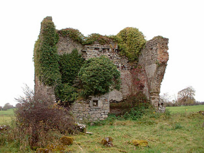
| Tristernagh House | Tristernagh Demesne | Kilbixy | Mullingar | Kilbixy 55 | Westmeath |
OSI Ref: N332616
OS Sheet: 11 Discovery map: 47 |
|
|
| Darlington Lodge | Tobercormick | Ballymorin | Mullingar | Ballymorin 60 | Westmeath |
OSI Ref: N267507
OS Sheet: 24 Discovery map: 41 |
||
| Ballyhast House | Ballyhast | Castletownkindalen | Mullingar | Castletown 61 | Westmeath |
OSI Ref: N322428
OS Sheet: 32 Discovery map: 48 |
||
| Shinglis House | Shinglis | Ballymore | Ballymahon | Winetown | Westmeath |
OSI Ref: N215516
OS Sheet: 17 Discovery map: 41 |
||
| Drumraney | Drumraney | Drumraney | Ballymahon | Drumraney | Westmeath |
OSI Ref: N170487
OS Sheet: 23 Discovery map: 48 |
Map of Estate Houses
Click on the markers to view more details about each house.
Archival sources
- Map of the estate of Richard Malone in Co. Westmeath, 1852. M. 2594; National Archives of Ireland
- Map of Ballallen and Cumminstown bogs, Co. Westmeath, the estate of Col. J. R. Malone. Surveyed by P. Menton. Folio sheet, coloured and mounted on linen, with names of tenants marked on allotments, Nov., 1900. 21 F. 80 (24); National Library of Ireland
- Documents relating to property and interests of Malone family in Co. Westmeath, 1619-1829. M. 6955; National Archives of Ireland
- Notes relating to the O'Malone family of Westmeath. Agreement of Mac Geoghegan and Fox. Extracts from the O'Reilly mss. in the Royal Irish Academy relating to Co. Wicklow, 19th c. Ms. 14. B. 4. (contd.) Microfilm copy in NLI P 5367; Royal Irish Academy Library
- Pedigree of Malone of Kilgarvan, Clonebonagh and Ballinahown and Cartrons, Co Westmeath. C 1500-1834. GO Ms 173, 198-207; National Library of Ireland
Contemporary printed sources
- PARLIAMENTARY PAPERS. ''Return of owners of land of one acre and upwards, in the several counties .... in Ireland''. HC 1876, LXXX: 85
- HUSSEY DE BURGH, U. H. ''The Landowners of Ireland. An alphabetical list of the owners of estates of 500 acres or £500 valuation and upwards in Ireland''. Dublin: Hodges, Foster and Figgis, 1878. [available online at www.askaboutireland.ie] : 304
- ''GRIFFITH'S VALUATION OF IRELAND'[Primary Valuation of Tenements]', 1850-1858. : Ballymahon Union, p.7
- PARLIAMENTARY PAPERS. ''Return of Untenanted Lands in Rural Districts, Distinguishing Demesnes on Which There is a Mansion...'', HC 1906, c, 177: p.183 (Shinglis, Rural District of Ballymore, County Westmeath); 368 (Baronstown, Rath and Tristernagh)
- LEET, Ambrose. ''A directory to the market towns, villages, gentlemen's seats, and other noted places in Ireland''. Dublin: Printed by B. Smith, 1814 : 23 (Ballynahown); 61 (Baronstown)
- TAYLOR, George & SKINNER, Andrew. ''Maps of the Roads of Ireland, surveyed in 1777 and corrected down to 1783''. Facsimile of 2nd edition. Shannon: Irish University Press, 1969: 63 (Baronstown); 75 (Ballynahown); 243 (Shinglas)
- ''GRIFFITH'S VALUATION OF IRELAND'[Primary Valuation of Tenements]', 1850-1858. : Mullingar Union, 6 (Baronstown and Oran Vale); 7 (Willybrook); 9 (Rath); 33 (Darlington Lodge); 97 (Ballyhast)
- LEWIS, Samuel. ''A Topographical Dictionary of Ireland''. London: S. Lewis & Co., 1837: II, 53
Modern printed sources
- O'Brien, Donal. ''The Houses and Landed Families of Westmeath''. The author, Athlone (2nd edition 2015): 26-28, 32-34, 228
- BURKE, Sir Bernard. ''A genealogical and heraldic history of the Landed Gentry of Ireland''. London: Harrison & Sons, 1904: 381-382
- Woods, James. ''Annals of Westmeath Ancient and Modern''. Dublin: Sealy, Bryers and Walker, (1907): 292-302
- O'Brien, Donal. ''The Houses and Landed Families of Westmeath''. The author, Athlone (2nd edition 2015): pp.171-172 (Shinglis House)