Pakenham
Henry Pakenham, born 1611, was granted lands in county Wexford and at Tullynally, county Westmeath in the mid-17th century. In 1739 his great-grandson, Thomas, married Elizabeth, daughter and sole heir of Michael Cuff and niece of Ambrose Aungier, 2nd and last Earl of Longford (1st creation). In 1756 he was created Baron Longford. In 1785 his wife became Countess of Longford. Their grandson, another Thomas, [3rd Baron], inherited the Earldom of Longford from his grandmother in 1794. At the time of Griffith’s Valuation (publ. 1854) Edward Michael Pakenham, 3rd Earl of Longford, owned a very extensive estate in the parish of Killucan, county Westmeath with much smaller acreages in the parishes of Castlelost, Killare and Rathgarve. In the mid-1870s the 4th Earl’s county Westmeath estate was recorded as amounting to 15,014 acres, with an estate of 4,555 acres in county Longford and 420 acres in county Dublin. The estate was among the principal lessors in the parishes of Ballymacormick and Templemichael in the baronies of Ardagh and Longford, County Longford and in the parishes of Mayne and Rathgarve, barony of Fore, County Westmeath The Honourable and Reverend Henry Pakenham was the fifth son of Edward Michael Pakenham, 2nd Baron Longford. In 1822 he married Eliza Catherine Sandford, sister and co -heiress of Henry Sandford, 2nd Lord Mountsandford. At the time of Griffith's Valuation the Pakenham estate in county Roscommon was in the parishes of Dysart and Fuerty, barony of Athlone, Kilbride and Roscommon, barony of Ballintober South and Ballintober, Baslick and Kilcorkey, barony of Castlereagh. It amounted to over 3,000 acres.
Associated Families
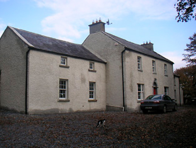
Houses
| Name | Townland | Civil Parish | PLU | DED | Barony | County | Map Ref | |
|---|---|---|---|---|---|---|---|---|
| Mullymucks/Fortview | Mullymucks | Kilbride | Roscommon | Roscommon Rural 90 | Ballintober South | Roscommon |
OSI Ref: M866676
OS Sheet: 20 Discovery map: 40 |
|
| Munsborough House | Mullymucks | Kilbride | Roscommon | Roscommon Rural 90 | Ballintober South | Roscommon |
OSI Ref: M870677
OS Sheet: 20 Discovery map: 40 |
|
| West View (Glandore) | Aghatubrid More | Kilfaughnabeg | Clonakilty | Kilfaughnabeg | East Carbery (West) | Cork |
OSI Ref: W218351
OS Sheet: 142 Discovery map: 89 |
|
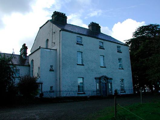
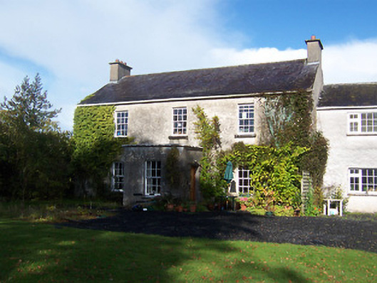
| Coolure | Coolure Demesne | Mayne | Granard | Coolure | Westmeath |
OSI Ref: N420695
OS Sheet: 7 Discovery map: 41 |
|
|
| Derrya | Derrya | Mayne | Granard | Coolure | Longford |
OSI Ref: N08692
OS Sheet: 7 Discovery map: 41 |
||
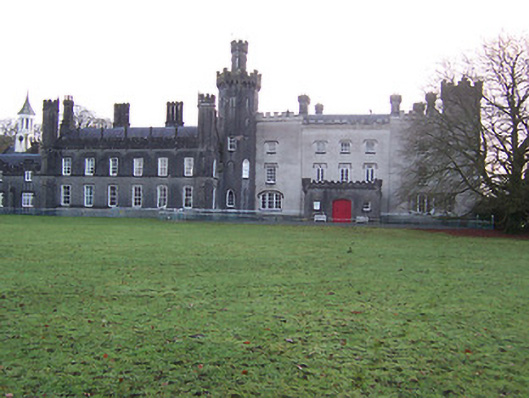
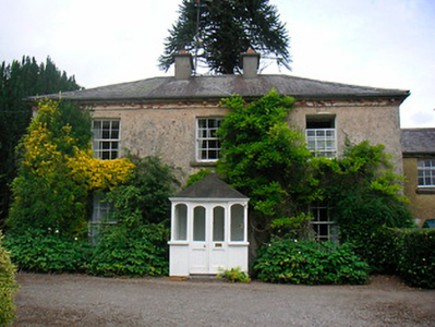
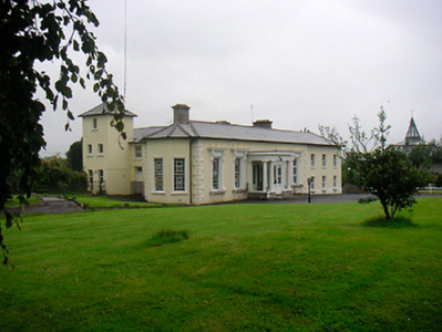
| Tullynally Castle | Pakenhamhall or Tullynally | Mayne | Granard | Coolure | Westmeath |
OSI Ref: N443704
OS Sheet: 3 Discovery map: 41 |
|
|
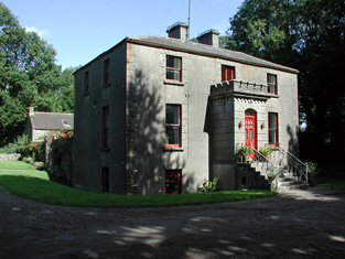
| Tromra House | Tromra | Rathgarve | Granard | Coolure | Westmeath |
OSI Ref: N453718
OS Sheet: 3 Discovery map: 41 |
|
|
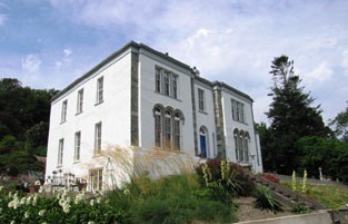
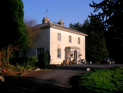
| Newtown House (Fore) | Newtown | Mayne | Granard | Coolure | Westmeath |
OSI Ref: N420715
OS Sheet: 3 Discovery map: 41 |
||
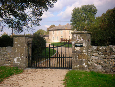
| Corbetstown | Corbetstown | Killucan | Mullingar | Raharney 73 | Westmeath |
OSI Ref: N578551
OS Sheet: 20 Discovery map: 42 |
|
|
| Riggs Villa/Greenhills | Killucan | Killucan | Mullingar | Killucan 71 | Westmeath |
OSI Ref: N567522
OS Sheet: 20 Discovery map: 42 |
|
|
| Woodfort | Newdown | Killucan | Mullingar | Heathstown 77 | Westmeath |
OSI Ref: N511504
OS Sheet: 27 Discovery map: 41 |
|
|
| Riverstown House | Rathwire Upper | Killucan | Mullingar | Killucan 71 | Westmeath |
OSI Ref: N564509
OS Sheet: 27 Discovery map: 42 |
|
|
| Cooksborough House | Cooksborough | Rathconnell | Mullingar | Cloghan 67 | Westmeath |
OSI Ref: N505545
OS Sheet: 20 Discovery map: 41 |
||
| Craddanstown Lodge | Craddanstown | Killucan | Castletowndelvin | Ballymaskeagh | Westmeath |
OSI Ref: N600547
OS Sheet: 21 Discovery map: 42 |
|
|
| Craddanstown House | Craddanstown | Killucan | Castletowndelvin | Ballymaskeagh | Westmeath |
OSI Ref: N597556
OS Sheet: 20 Discovery map: 42 |
|
|
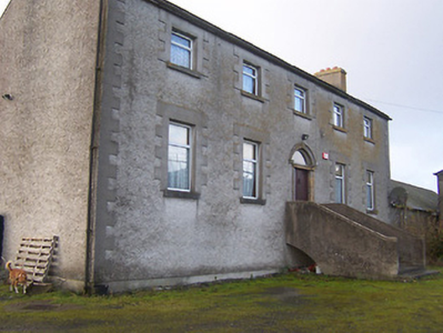
| Greenfield House | Lisnamuck | Templemichael | Longford | Longford Rural | Longford |
OSI Ref: N149763
OS Sheet: 14 Discovery map: |
Map of Estate Houses
Click on the markers to view more details about each house.
Contemporary printed sources
- ''GRIFFITH'S VALUATION OF IRELAND'[Primary Valuation of Tenements]', 1850-1858. : Roscommon Union, 88
- PARLIAMENTARY PAPERS. ''Return of names of proprietors and area and valuation of properties in counties in Ireland, held in fee or perpetuity or long leases at chief rents,'' 1876. (412) LXXX. 395: 163
- ''GRIFFITH'S VALUATION OF IRELAND'[Primary Valuation of Tenements]', 1850-1858. : East Carbery (West) Barony: 147 (Aghatubrid More)
- ''GRIFFITH'S VALUATION OF IRELAND'[Primary Valuation of Tenements]', 1850-1858. : Longford Union, p.63 (Ardnacassagh)
- ''GRIFFITH'S VALUATION OF IRELAND'[Primary Valuation of Tenements]', 1850-1858. : Granard Union, p.19 (Coolure), p.20 (Lispopple), p.22 (Newtown & Pakenamhall), p.24 ((Tromra)
- PARLIAMENTARY PAPERS. ''Return of Untenanted Lands in Rural Districts, Distinguishing Demesnes on Which There is a Mansion...'', HC 1906, c, 177: p.154 (Longford Rural District), p.184 (Coole Rural District, Westmeath)
- HUSSEY DE BURGH, U. H. ''The Landowners of Ireland. An alphabetical list of the owners of estates of 500 acres or £500 valuation and upwards in Ireland''. Dublin: Hodges, Foster and Figgis, 1878. [available online at www.askaboutireland.ie] : 278
- PARLIAMENTARY PAPERS. ''Return of owners of land of one acre and upwards, in the several counties .... in Ireland''. HC 1876, LXXX: 84
- ''GRIFFITH'S VALUATION OF IRELAND'[Primary Valuation of Tenements]', 1850-1858. : Mullingar Union, 162 (Corbetstown), 172 (Killucan), 179 (Newdown), 183 (Rathwire Upper)
- LEET, Ambrose. ''A directory to the market towns, villages, gentlemen's seats, and other noted places in Ireland''. Dublin: Printed by B. Smith, 1814 : 335
- ''GRIFFITH'S VALUATION OF IRELAND'[Primary Valuation of Tenements]', 1850-1858. : Castletowndelvin Union, 78 (Craddanstown)
- TAYLOR, George & SKINNER, Andrew. ''Maps of the Roads of Ireland, surveyed in 1777 and corrected down to 1783''. Facsimile of 2nd edition. Shannon: Irish University Press, 1969: 249 (Pakenham Hall)
Modern printed sources
- BURKE, Sir Bernard. ''A genealogical and heraldic history of the Landed Gentry of Ireland''. London: Harrison & Sons, 1912: 451-452.
- MOSLEY, Charles (ed). ''Burke's Peerage and Baronetage''. Crans, Switzerland: Burke's Peerage (Genealogical Books) Ltd, 1999: II, 1750-1756
- ''Analecta Hibernica'': Report on Longford paper, diaries, letters, deeds, maps and plans, account books etc. 1655-early 20th century relating to members of the Pakenham family, Earls of Longford. Supplement to Analecta Hibernia, no. 15, pp.111-127.
- O'Brien, Donal. ''The Houses and Landed Families of Westmeath''. The author, Athlone (2nd edition 2015): 54, 116