Barony: Corran
Houses
Displaying 26 houses.
| Name | Townland | Civil Parish | PLU | DED | Barony | County | Map Ref | |
|---|---|---|---|---|---|---|---|---|
| Old Rock | Shancarrigeen or Old Rock | Cloonoghill | Tobercurry | Cloonoghil 79 | Corran | Sligo |
OSI Ref: G630139
OS Sheet: 33 (house not marked) Discovery map: 25 |
|
| Knockalass House | Knockalass | Kilturra | Tobercurry | Kilturra | Corran | Sligo |
OSI Ref: G605099
OS Sheet: 38 Discovery map: 25 |
|
| Mount Dodwell | Ballinvoher | Toomour | Sligo | Bricklieve 32 | Corran | Sligo |
OSI Ref: G705151
OS Sheet: 33 Discovery map: |
|
| Kilturra | Kilturra | Kilturra | Tobercurry | Kilturra | Corran | Sligo |
OSI Ref: G604089
OS Sheet: 38 Discovery map: 32 |
|
| Templevanny | Templevanny | Toomour | Boyle | Templevanny | Corran | Sligo |
OSI Ref: G734099
OS Sheet: 40 Discovery map: 33 |
|
| Kilmorgan | Kilmorgan | Kilmorgan | Sligo | Drumfin | Corran | Sligo |
OSI Ref: G716172
OS Sheet: 34 Discovery map: 25 |
|
| Drimrane | Drimrane | Cloonoghil | Tobercurry | Owenmore 76 | Corran | Sligo |
OSI Ref: G613159
OS Sheet: 32 Discovery map: 25 |
|
| Keenaghan Mill | Keenaghan | Emlaghfad | Sligo | Ballymote | Corran | Sligo |
OSI Ref: G663151
OS Sheet: 33 Discovery map: 25 |
|
| Kilcreevin | Kilcreevin | Kilmorgan | Sligo | Drumfin | Corran | Sligo |
OSI Ref: G690186
OS Sheet: 33 Discovery map: 25 |
|
| Quarryfield | Quarryfield | Clonoghil | Tobercurry | Kilturra 81 | Corran | Sligo |
OSI Ref: G598100
OS Sheet: 38 Discovery map: 25 |
|
| Battlefield | Battlefield | Toomour | Boyle | Drumrat 10 | Corran | Sligo |
OSI Ref: G696079
OS Sheet: 39 Discovery map: 32 |
|
| Atteville | Attiville | Kilshalvy | Boyle | Drumrat 10 | Corran | Sligo |
OSI Ref: G681083
OS Sheet: 39 Discovery map: 32 |
|
| Brick Field | Knockbrack | Drumrat | Boyle | Toomour 13 | Corran | Sligo |
OSI Ref: G694102
OS Sheet: 39 Discovery map: 25 |
|
| Greyfort | Lislea | Cloonoghill | Tobercurry | Owenmore 76 | Corran | Sligo |
OSI Ref: G605161
OS Sheet: 32 Discovery map: 25 |
|
| Derroon House | Derroon | Emlaghfad | Sligo | Ballymote | Corran | Sligo |
OSI Ref: G660168
OS Sheet: 33 Discovery map: 25 |
|
| Newpark | Newpark | Kilmorgan | Sligo | Drumfin 34 | Corran | Sligo |
OSI Ref: G698184
OS Sheet: 33 Discovery map: 25 |
|
| Larkhill | Quarryfield | Cloonoghil | Tobercurry | Kilturra 81 | Corran | Sligo |
OSI Ref: G588107
OS Sheet: 38 Discovery map: 25 |
|
| Cloonshanbally | Cloonshanbally | Drumrat | Boyle | Drumrat 10 | Corran | Sligo |
OSI Ref: G691085
OS Sheet: 39 Discovery map: 32 |
|
| Flower Hill | Flower Hill | Cloonoghil | Tobercurry | Cloonoghil 79 | Corran | Sligo |
OSI Ref: G603124
OS Sheet: 38 (house not marked) Discovery map: 25 |
|
| Branchfield (Duke) | Branchfield | Kilmorgan | Sligo | Drumfin | Corran | Sligo |
OSI Ref: G690191
OS Sheet: Discovery map: 25 |
|
| Doobeg | Doobeg | Kilturra | Tobercurry | Kilturra 81 | Corran | Sligo |
OSI Ref: G591093
OS Sheet: 38 Discovery map: 32 |
|
| Roadstown | Ballinvally or Roadstown | Cloonoghil | Tobercurry | Cloonoghil 79 | Corran | Sligo |
OSI Ref: G583115
OS Sheet: 38 Discovery map: 25 |
|
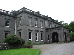
| Temple House | Temple House Demesne | Kilvarnet | Tobercurry | Temple 77 | Corran | Sligo |
OSI Ref: G618185
OS Sheet: 33 Discovery map: 25 |
|
| Earlsfield | Carrowcauly or Earlsfield | Emlaghfad | Sligo | Ballymote 31 | Corran | Sligo |
OSI Ref: G664164
OS Sheet: 33 Discovery map: 25 |
|
| Abbeyville | Abbeyville or Ardlaherty | Drumrat | Boyle | Drumrat 10 | Corran | Sligo |
OSI Ref: G678123
OS Sheet: 39 Discovery map: 25 |
|
| Carrowkeel | Carrowkeel | Emlaghfad | Tobercurry | Owenmore 76 | Corran | Sligo |
OSI Ref: G626153
OS Sheet: 33 Discovery map: 25 |