Lyons (Ladestown)
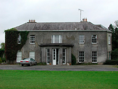
According to both Woods and Burkes Ladestown, county Westmeath, was purchased by Major John Lyons in 1715. It was bought from Randal Adams who was granted large tracts of land in September 1666 forfeited by Richard Hope. John Lyons also purchased land from an adventurer, William Henman, a London goldsmith. In 1769, he built a new front onto the old castle at Ladestown. His descendant Captain Charles John Lyons married Mary Anne, youngest daughter of Sir Richard Levinge 4th Baronet and they had an only child John Charles Lyons who was one of the principle lessors in the parish of Mullingar at the time of Griffith’s Valuation (publ. 1854). His son, also named John Charles Lyons ‘(a minor)’ owned 1,357 acres in county Westmeath and 397 acres in county Meath in the 1870s.
Associated Families
Houses
| Name | Townland | Civil Parish | PLU | DED | Barony | County | Map Ref | |
|---|---|---|---|---|---|---|---|---|
| Charlestown House | Balnamona or Charlestown | Mullingar | Mullingar | Mullingar Rural 85 | Westmeath |
OSI Ref: N409516
OS Sheet: 19 Discovery map: 41 |
||
| Bellmount House | Curristown or Belmount | Mullingar | Mullingar | Hopestown | Westmeath |
OSI Ref: N391508
OS Sheet: 25 Discovery map: 41 |
|
|
| Lakefield/Keoltown House | Keoltown | Mullingar | Mullingar | Hopestown | Westmeath |
OSI Ref: N388496
OS Sheet: 25 Discovery map: 48 |
|
|
| Ladestown | Ladestown | Mullingar | Mullingar | Hopestown | Westmeath |
OSI Ref: N402493
OS Sheet: 25 Discovery map: 48 |
|
Map of Estate Houses
Click on the markers to view more details about each house.
Archival sources
- Map of lands at Ladestown, Co. Westmeath, the Lyons estate. Folio linen sheet, 1858. 21 F. 80 (18); National Library of Ireland
- Maps of the estate of J. C. Lyons, in the barony of Moygashel and Magheradernon, Co. Westmeath, (after 1823). Ms. 2753; National Library of Ireland
- Workmen's and servants' wages book of the estate of John Lyons (of Ladestown, Co. Westmeath), 1820 - 1874. Ms. 4248; National Library of Ireland
- Rent roll and timber accounts of a Co. Westmeath estate (of the Lyons family?) in the barony of Moygashel and Magheradernon, 1786 - 1792. Ms. 4249; National Library of Ireland
- Map of the lands of William Geoghegan, near Mullingar, Co. Westmeath. Surveyed by Owen Houlton. (Lyons Estate map). April, 1834. 21 F. 80(23); National Library of Ireland
- Genealogical documents relating to the family of Lyons, of Ladestown, Co. Westmeath, together with documents relating to their estates and to the county, 1683 - 1853. Ms. 8667; National Library of Ireland
- A map of the demesne of Ladestown, Co. Westmeath, the estate of John Charles Lyons. Surveyed by James Duffy. Folio sheet, 1841. 21 F. 80 (20); National Library of Ireland
- Map of Ladistown, Co Westmeath, the demesne of J C Lyons. Sketched and drawn by H S S Stephens, Lt 29th Regt, June 1823. 21 F. 80 (21); National Library of Ireland
- Survey of Clown in the parish of Mullingar, Co. Westmeath, the estate of John Charles Lyons by Brassington and Gale. Folio sheet, coloured, with names of tenants, 1834. 21 F. 80 (15); National Library of Ireland
- Map of the lands of William Geoghegan, near Mullingar, Co. Westmeath. Surveyed by Owen Houlton. (Lyons Estate map). Folio sheet, April, 1834. 21 F. 80 (23); National Library of Ireland
- Map of part of the lands of Grange, Burlemona or Charlestown and Belmont, Co. Westmeath, the estate of John Lyons taken for the use of the Royal Canal. By F. A. Jones. 1806. 21 F. 80 (17); National Library of Ireland
- A map of lands adjoining Ladystown (Ladestown), in the parish of Mullingar, Co. Westmeath, the estate of Major John Lyons. Surveyed by John Nelson. Oblong quarto vellum sheet, coloured in outline, 1715. 21 F. 80 (16); National Library of Ireland
- Forty-four leases and renewals relating to properties of the family of Lyons of Ledestown, Mullingar, Co. Westmeath, 1723-1864. D. 9799-9842; National Library of Ireland
- Twenty-five deeds, bonds, appointments, etc. relating to the affairs of the family of Lyons of Ledestown, Mullingar, Co. Westmeath, including a copy of the 1565 charter of Phillipstown, 18th - 19th c. D. 9843-9867; National Library of Ireland
- Draft pedigree of Lyons of Killeen and Cloncarrow, King’s Co and of Lederstown, Co Westmeath, 1633-1780. GO Ms 812, 41; National Library of Ireland
- Map of lands adjoining Ladestown demesne, surveyed by Owen Houlton, July 1825. 21 F 80 (21); National Library of Ireland
Contemporary printed sources
- PARLIAMENTARY PAPERS. ''Return of owners of land of one acre and upwards, in the several counties .... in Ireland''. HC 1876, LXXX: 84
- HUSSEY DE BURGH, U. H. ''The Landowners of Ireland. An alphabetical list of the owners of estates of 500 acres or £500 valuation and upwards in Ireland''. Dublin: Hodges, Foster and Figgis, 1878. [available online at www.askaboutireland.ie] : 284
- LEET, Ambrose. ''A directory to the market towns, villages, gentlemen's seats, and other noted places in Ireland''. Dublin: Printed by B. Smith, 1814 : 66 (Bellmount), 104 (Charlestown), 258 (Ladestown)
- ''GRIFFITH'S VALUATION OF IRELAND'[Primary Valuation of Tenements]', 1850-1858. : Mullingar Union, 208 (Balnamona); 216 (Keoltown); 217 (Ladestown)
- LEWIS, Samuel. ''A Topographical Dictionary of Ireland''. London: S. Lewis & Co., 1837: II, 412 (Ladestown)
- TAYLOR, George & SKINNER, Andrew. ''Maps of the Roads of Ireland, surveyed in 1777 and corrected down to 1783''. Facsimile of 2nd edition. Shannon: Irish University Press, 1969: 250 (Ladestown)
- PARLIAMENTARY PAPERS. ''Return of Untenanted Lands in Rural Districts, Distinguishing Demesnes on Which There is a Mansion...'', HC 1906, c, 177: 367
Modern printed sources
- BURKE, Sir Bernard. ''A genealogical and heraldic history of the Landed Gentry of Ireland''. London: Harrison & Sons, 1904: 356-357
- Woods, James. ''Annals of Westmeath Ancient and Modern''. Dublin: Sealy, Bryers and Walker, (1907): 68
- O'Brien, Donal. ''The Houses and Landed Families of Westmeath''. The author, Athlone (2nd edition 2015): 34, 127, 137