Bomford (Oakley Park)
The Bomford estate was mainly located in county Meath but the Bomford family also held some land in the parish of Killucan, county Westmeath. George Bomford was the proprietor at the time of Griffith’s Valuation (publ. 1854). In the mid-1870s he owned 443 acres in county Westmeath and 2,436 acres in county Meath. This family descend from Laurence Bomford who was living at Clonmahon, county Meath, by the end of the 17th century. See http://www.bomford.net/IrishBomfords/index.htm
Associated Families
Houses
| Name | Townland | Civil Parish | PLU | DED | Barony | County | Map Ref | |
|---|---|---|---|---|---|---|---|---|
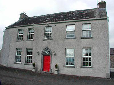
| Tyrrellstown | Tyrrellstown | Moylisker | Mullingar | Belvidere 80 | Westmeath |
OSI Ref: N444463
OS Sheet: 26 Discovery map: 48 |
|
Map of Estate Houses
Click on the markers to view more details about each house.
Contemporary printed sources
- HUSSEY DE BURGH, U. H. ''The Landowners of Ireland. An alphabetical list of the owners of estates of 500 acres or £500 valuation and upwards in Ireland''. Dublin: Hodges, Foster and Figgis, 1878. [available online at www.askaboutireland.ie] : p.44
- PARLIAMENTARY PAPERS. ''Return of owners of land of one acre and upwards, in the several counties .... in Ireland''. HC 1876, LXXX: p.82 [Westmeath]
- LEWIS, Samuel. ''A Topographical Dictionary of Ireland''. London: S. Lewis & Co., 1837: II, 403 (Tyrrellstown)
- LEET, Ambrose. ''A directory to the market towns, villages, gentlemen's seats, and other noted places in Ireland''. Dublin: Printed by B. Smith, 1814 : 382