Pilkington (Tore)
According to Burke’s Landed Gentry Richard Pilkington acquired ‘extensive property’ in Westmeath and King’s County (Offaly) at the end of the 17th century and settled at Rathgarrett or Tore. O’Brien gives a detailed account of this family. At the time of Griffith’s Valuation (publ. 1854) family members held lands in the parishes of Clonfad, Kilbride and Newtown. In the 1870s Henry Mulock Pilkington of Tore owned 89 acres in King’s County and 1,683 acres in county Westmeath while William Pilkington of Kilbride owned 376 acres.
Associated Families
Houses
| Name | Townland | Civil Parish | PLU | DED | Barony | County | Map Ref | |
|---|---|---|---|---|---|---|---|---|
| Calverstown | Calverstown | Clonfad | Mullingar | Clonfad 100 | Westmeath |
OSI Ref: N410418
OS Sheet: 33 Discovery map: 48 |
|
|
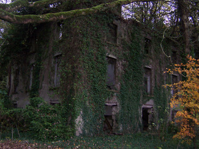
| Dalystown | Dalystown | Clonfad | Mullingar | Clonfad 100 | Westmeath |
OSI Ref: N395425
OS Sheet: 32 Discovery map: 48 |
|
|
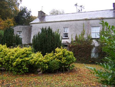
| Kilbride | Kilbride | Kilbride | Mullingar | Carrick 98 | Westmeath |
OSI Ref: N441439
OS Sheet: 33 Discovery map: 48 |
|
|
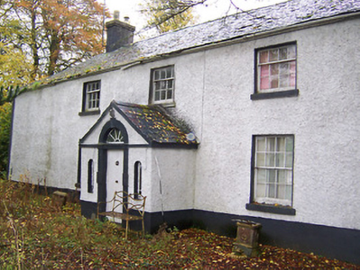
| Dunboden Park | Kilbride | Kilbride | Mullingar | Carrick 98 | Westmeath |
OSI Ref: N436445
OS Sheet: 33 Discovery map: 48 |
|
|
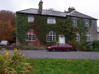
| Tore | Rathgarrett | Newtown | Mullingar | Ballykilmore | Westmeath |
OSI Ref: N428366
OS Sheet: 39 Discovery map: 48 |
Map of Estate Houses
Click on the markers to view more details about each house.
Archival sources
- Messrs. Newton, Dungannon estate agents papers, include a box of documents relating to the Pilkington family, Tore, Co. Westmeath, and related families, 1704-c 1900. D2138/17/1; Public Record Office, Northern Ireland
- Maps of the estate of Henry Pilkington in Rathgarret, Co. Westmeath by T. Bourke, 1726, in part of Fore, Co. Westmeath, by C. Carleton, 1745, by C. Dunne, 1764, by J. Dunne, 1778, 1790, with notes of acreages 1778. D. 474 (98-103); Public Record Office, Northern Ireland
- Late 19th - 20th c. documents, including draft rentals, concerning disposal of the estates, in Dublin cities, King's Co., Westmeath, etc., of Richard Coffey, Richard Pilkington, etc. Ms. 15,412; National Library of Ireland
Contemporary printed sources
- PARLIAMENTARY PAPERS. ''Return of owners of land of one acre and upwards, in the several counties .... in Ireland''. HC 1876, LXXX: 85
- HUSSEY DE BURGH, U. H. ''The Landowners of Ireland. An alphabetical list of the owners of estates of 500 acres or £500 valuation and upwards in Ireland''. Dublin: Hodges, Foster and Figgis, 1878. [available online at www.askaboutireland.ie] : 368
- ''GRIFFITH'S VALUATION OF IRELAND'[Primary Valuation of Tenements]', 1850-1858. : Mullingar Union, 132 (Calverstown); 133 (Dalystown); 141 (Kilbride); 153 (Rathgarrett)
- LEWIS, Samuel. ''A Topographical Dictionary of Ireland''. London: S. Lewis & Co., 1837: liv; I, 361
- TAYLOR, George & SKINNER, Andrew. ''Maps of the Roads of Ireland, surveyed in 1777 and corrected down to 1783''. Facsimile of 2nd edition. Shannon: Irish University Press, 1969: 74