Bannon (Rathconrath)
At the time of Griffith’s Valuation, Christopher Bannon held land in the parish of Rathconrath, county Westmeath, 75 acres at Sheean and 400 acres at Irishtown while Thomas Bannon held 21 acres in Skeaghmore from James Fallon.
Associated Families
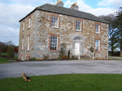
Houses
| Name | Townland | Civil Parish | PLU | DED | Barony | County | Map Ref | |
|---|---|---|---|---|---|---|---|---|
| Irishtown | Irishtown | Rathconrath | Mullingar | Skeagh 58 | Westmeath |
OSI Ref: N295565
OS Sheet: Discovery map: 41 |
||
| Rathcastle | Rathcastle | Rathconrath | Mullingar | Skeagh 58 | Westmeath |
OSI Ref: N281548
OS Sheet: 17 Discovery map: 41 |
|
|
| Oldtown | Skeagh More | Rathconrath | Mullingar | Skeagh 58 | Westmeath |
OSI Ref: N285544
OS Sheet: 17 Discovery map: 41 |
Map of Estate Houses
Click on the markers to view more details about each house.
Archival sources
- A map of Rathcastle and Rowlandstown in the barony of Rathconrath and County Westmeath the estate of Thomas Bannon. Surveyed by J.L. 1809. Table of reference showing tenants and acreage of holdings. Scale 10 perches to an inch. MS 21 F. 48 (19); National Library of Ireland
- Encumbered Estates' Court Rentals (O'Brien), Banon, 19 Dec 1851, Vol 12 (37), MRGS 39/005, (microfilm copy in UG) Oldtown House and 13 acres; National Archives of Ireland
Contemporary printed sources
- ''GRIFFITH'S VALUATION OF IRELAND'[Primary Valuation of Tenements]', 1850-1858. : Mullingar Union, 53 (Irishtown); 57 (Skeagh More)
- TAYLOR, George & SKINNER, Andrew. ''Maps of the Roads of Ireland, surveyed in 1777 and corrected down to 1783''. Facsimile of 2nd edition. Shannon: Irish University Press, 1969: 62, 66 (Johnston)
- LEWIS, Samuel. ''A Topographical Dictionary of Ireland''. London: S. Lewis & Co., 1837: II, 491 (Rathcastle)
- PARLIAMENTARY PAPERS. ''Return of Untenanted Lands in Rural Districts, Distinguishing Demesnes on Which There is a Mansion...'', HC 1906, c, 177: 370