McMath/M'Math
This family were located in the Castleblayney area of county Monaghan and were involved in brewing, milling and farming. Andrew McMath of Aghadreenan is mentioned in a deed of 1785. In the mid-19th century Hamilton M’Math of Thornford in the townland of Aghadreenan held land in the parish of Donaghmoyne and with his brother Andrew M’Math held a number of townlands in the parish of Aghnamullen. In 1876, Hamilton M’Math’s representatives owned 834 acres in the county while Andrew M’Math owned 595 acres and a further 187 acres in county Armagh.
Associated Families
No associated families were found for this estate
Houses
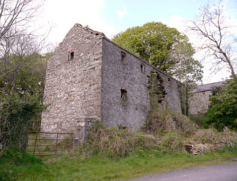
| Name | Townland | Civil Parish | PLU | DED | Barony | County | Map Ref | |
|---|---|---|---|---|---|---|---|---|
| Thornford | Aghadreenan | Donaghmoyne | Castleblayney | Broomfield | Farney | Monaghan |
OSI Ref: H839150
OS Sheet: 25 Discovery map: 28B |
|
Map of Estate Houses
Click on the markers to view more details about each house.
Archival sources
- Genealogical Office report on McMath of Derry and Co. Monaghan, 1643 -- 1848. GO Ms 819(25); National Library of Ireland
- Rental of the estate in Co. Monaghan of Messrs McMath and Douglas and the Co. Armagh estate of Messrs Barton, Wallace and Hamilton. November 1874-November 1892. D2784/12/1A; Public Record Office, Northern Ireland
- Rental of the estate in Cos Armagh and Monaghan of Messrs Barton, Wallace and Hamilton and the Co. Armagh estate of Messrs McMath and Douglas, September 1893-November 1898. D2784/12/1B; Public Record Office, Northern Ireland
- Volume of maps of Tievaleny, Formil, Tullynaboy, Kilkit and Lisdrumcleve, the estate of Hamilton and Andrew McMath; surveyed by Owen Hall, scale 20 Irish plantation perches to 1 inch. Reference tables list the names of tenants and the acreages. A survey of these townlands appears at the front of the volume and a sketch map of part of Lisdrumcleve and a map of Garrybane appear at the back, 1849. D3531/S/69; Public Record Office, Northern Ireland
Contemporary printed sources
- ''GRIFFITH'S VALUATION OF IRELAND'[Primary Valuation of Tenements]', 1850-1858. : Castleblayney Union, 32, 131
- LEWIS, Samuel. ''A Topographical Dictionary of Ireland''. London: S. Lewis & Co., 1837: I, 446 (Laurel Hill House), 470 (Thornford)
- ORDNANCE SURVEY NAME BOOKS, County Monaghan: I, 403 (Thornford)
- HUSSEY DE BURGH, U. H. ''The Landowners of Ireland. An alphabetical list of the owners of estates of 500 acres or £500 valuation and upwards in Ireland''. Dublin: Hodges, Foster and Figgis, 1878. [available online at www.askaboutireland.ie] : 298