Barry (Kilbarry)
"The Londonderry Journal" (20 June 1772) records the killing in county Cork of Garret Barry, son of William Barry of Kilbarry, by Daniel Punch of Glasheen. At the time of Griffith's Valuation Nicholas Barry held a townland in the parishes of Inchigeelagh and Kilmichael, barony of West Muskerry, county Cork. James Redmond Barry of Dublin held over 400 acres in county Cork in the 1870s. He was among the principal lessors in the parish of Kilfaughnabeg, barony of East Carbery, at the time of Griffith's Valuation.
Associated Families
Houses
| Name | Townland | Civil Parish | PLU | DED | Barony | County | Map Ref | |
|---|---|---|---|---|---|---|---|---|
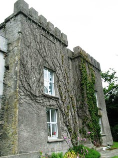
| Kilbarry House | Carrignaneelagh | Inchigeelagh | Macroom | Inchigeelagh 222 | West Muskerry | Cork |
OSI Ref: W265 677
OS Sheet: 82 Discovery map: 86 |
|
| Glandore Lodge | Aghatubrid Beg | Kilfaughnabeg | Clonakilty | Kilfaughnabeg 19 | East Carbery (West) | Cork |
OSI Ref: W223355
OS Sheet: 142 Discovery map: 89 |
|
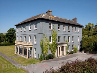
| Glandore Castle | Aghatubrid More | Kilfaughnabeg | Clonakilty | Kilfaughnabeg 319 | East Carbery (West) | Cork |
OSI Ref: W222355
OS Sheet: 142 Discovery map: 89 |
|
| Glandore House | Rushanes | Kilfaughnabeg | Clonakilty | Kilfaughnabeg 319 | East Carbery (West) | Cork |
OSI Ref: W225354
OS Sheet: 143 Discovery map: 89 |
|
| Glandore Cottage | Rushanes | Kilfaughnabeg | Clonakilty | Kilfaughnabeg 319 | East Carbery (West) | Cork |
OSI Ref: W226353
OS Sheet: 142 Discovery map: 89 |
Map of Estate Houses
Click on the markers to view more details about each house.
Archival sources
- Volume of maps of the estate of Michael Francis Barry near Macroom, c. 1880. U.193 ; Cork City and County Archives
- Deed between K. Barry and W. Harvey relating to the lands of Kilbarry, Co. Cork, Jan. 20, 1716 (1717). D. 19,436 ; National Library of Ireland
- Irish Tourist Association Survey, Parish of Kilmacbea; Cork County Library
Contemporary printed sources
- ''GRIFFITH'S VALUATION OF IRELAND'[Primary Valuation of Tenements]', 1850-1858. : Barony of West Muskerry, 74 (Carrignaneelagh)
- LEWIS, Samuel. ''A Topographical Dictionary of Ireland''. London: S. Lewis & Co., 1837: II, 15 (Kilbarry), II, 90 (Kilfaughnabeg Parish)
- TAYLOR, George & SKINNER, Andrew. ''Maps of the Roads of Ireland, surveyed in 1777 and corrected down to 1783''. Facsimile of 2nd edition. Shannon: Irish University Press, 1969: 176 (Carronageelough)
- ''GRIFFITH'S VALUATION OF IRELAND'[Primary Valuation of Tenements]', 1850-1858. : Barony of East Carbery (West): 146 (Aghatubrid Beg), 147 (Aghatubrid More), 155 (Rushanes)