Barony: Farbill
Houses
Displaying 19 houses.
| Name | Townland | Civil Parish | PLU | DED | Barony | County | Map Ref | |
|---|---|---|---|---|---|---|---|---|
| Annaskinnan | Annaskinnan | Killucan | Mullingar | Derrymore 69 | Westmeath |
OSI Ref: N588498
OS Sheet: 27 Discovery map: 49 |
||
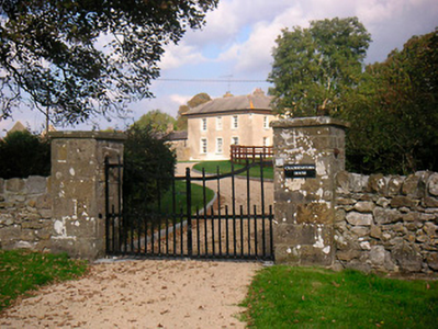
| Corbetstown | Corbetstown | Killucan | Mullingar | Raharney 73 | Westmeath |
OSI Ref: N578551
OS Sheet: 20 Discovery map: 42 |
|
|
| Curristown | Curristown | Killucan | Mullingar | Killucan 71 | Westmeath |
OSI Ref: N580516
OS Sheet: 20 Discovery map: 42 |
|
|
| Derrymore | Derrymore | Killucan | Mullingar | Derrymore 69 | Westmeath |
OSI Ref: N605507
OS Sheet: 28 Discovery map: 42 |
||
| Griffinstown | Griffinstown | Killucan | Mullingar | Griffinstown 73 | Westmeath |
OSI Ref: N565464
OS Sheet: 27 Discovery map: 49 |
|
|
| Huntingdon | Huntingdon | Killucan | Mullingar | Huntingdon 70 | Westmeath |
OSI Ref: N543537
OS Sheet: 20 Discovery map: 42 |
|
|
| Hydepark | Hydepark | Killucan | Mullingar | Derrymore 69 | Westmeath |
OSI Ref: N597497
OS Sheet: 27 Discovery map: 49 |
|
|
| Joristown | Joristown Upper | Killucan | Mullingar | Raharney 73 | Westmeath |
OSI Ref: N590533
OS Sheet: 20 Discovery map: 42 |
|
|
| Riggs Villa/Greenhills | Killucan | Killucan | Mullingar | Killucan 71 | Westmeath |
OSI Ref: N567522
OS Sheet: 20 Discovery map: 42 |
|
|
| Lisnabin Castle | Lisnabin | Killucan | Mullingar | Killucan 71 | Westmeath |
OSI Ref: N553530
OS Sheet: 20 Discovery map: 42 |
|
|
| Lowtown House | Lowtown or Balleighter | Killucan | Mullingar | Griffithstown 73 | Westmeath |
OSI Ref: N545468
OS Sheet: 27 Discovery map: 49 |
||
| Woodfort | Newdown | Killucan | Mullingar | Heathstown 77 | Westmeath |
OSI Ref: N511504
OS Sheet: 27 Discovery map: 41 |
|
|
| Riverstown House | Rathwire Upper | Killucan | Mullingar | Killucan 71 | Westmeath |
OSI Ref: N564509
OS Sheet: 27 Discovery map: 42 |
|
|
| Wardenstown | Wardenstown | Killucan | Mullingar | Derrymore 69 | Westmeath |
OSI Ref: N594516
OS Sheet: 20 Discovery map: 42 |
|
|
| Craddanstown House | Craddanstown | Killucan | Castletowndelvin | Ballymaskeagh | Westmeath |
OSI Ref: N597556
OS Sheet: 20 Discovery map: 42 |
|
|
| Craddanstown Lodge | Craddanstown | Killucan | Castletowndelvin | Ballymaskeagh | Westmeath |
OSI Ref: N600547
OS Sheet: 21 Discovery map: 42 |
|
|
| Grange Beg House | Grange Beg | Killucan | Castletowndelvin | Riverdale 44 | Westmeath |
OSI Ref: N609515
OS Sheet: 21 Discovery map: 42 |
|
|
| Grange More House | Grange More | Killucan | Castletowndelvin | Riverdale 44 | Westmeath |
OSI Ref: N611543
OS Sheet: 21 Discovery map: 42 |
||
| Riverdale | Riverdale | Killucan | Castletowndelvin | Riverdale 44 | Westmeath |
OSI Ref: N616510
OS Sheet: 28 Discovery map: 42 |